Las Matas geodata
Las Matas (Coclé) is a populated place; located in Panama in America/Panama (GMT-5) time zone. With population of 522 people, there are 470 cities with bigger population in this country. Compared to other cities in Panama, 50.1% of cities are located further ↑North; 70.9% of cities are located further ←West and 69.5% of cities have lower elevation than Las Matas. Note1


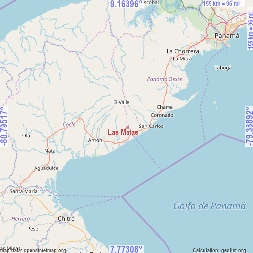
Las Matas GPS coordinates[2]
8° 28' 8.94" North, 80° 5' 31.344" West
| Map corner | latitude | longitude |
|---|---|---|
| Upper-left | 9.16396°, | -80.79517° |
| Center: | 8.46915°, | -80.09204° |
| Lower-right: | 7.77308°, | -79.38892° |
| Map W x H: | 154.7×154.7 km | = 96.1×96.1mi |
| max Lat: | 9.60898° ⇑50.1% North |
| Las Matas: | 8.46915° |
| min Lat: | ⇓49.9% South 7.26534° |
| min Long | Las Matas | max Long |
| -82.91275° | -80.09204° | -77.38965° |
| W 70.9%⇐ | ⇒29.1% E |
Elevation
Elevation of Las Matas is 153 m = 502 ft, and this is 19.1 m = 63 ft below average elevation for this country.
| Max E: |
2103 m = 6900 ft | 30.5% |
| Avg. | 172.1 m = 565 ft | |
| Las Matas | 153 m = 502 ft | |
Min E: |
-1 m = -3 ft | 69.5% |
See also: Panama elevation on elevation.city.
Geographical zone
Las Matas is located in North Torrid zone (between Equator and Tropic of Cancer). Distance of Equator is 941.7 km =585.1 mi to South.| Distance of | km | miles | from Las Matas |
|---|---|---|---|
| North Pole | 9065.4 | 5633 | to North |
| Arctic Circle | 6459.5 | 4013.7 | to North |
| Tropic Cancer | 1664.2 | 1034.1 | to North |
| Equator | 941.7 | 585.1 | to South |


Nearby cities:
15 places around Las Matas: (largest is in red/bold)
• Cabuya
12 km =7.5 mi,  316°
316°
• El Chirú
13.1 km =8.1 mi,  233°
233°
• El Espino
8.8 km =5.5 mi,  83°
83°
• El Higo
6.6 km =4.1 mi,  111°
111°
• El Nance
13.9 km =8.6 mi,  89°
89°
• El Retiro
7 km =4.3 mi,  280°
280°
• Farallón
13.5 km =8.4 mi,  201°
201°
• Guayabito
12.3 km =7.6 mi,  44°
44°
• La Ermita
3 km =1.9 mi,  118°
118°
• Las Colinas
9 km =5.6 mi,  6°
6°
• Las Uvas
10.1 km =6.3 mi,  96°
96°
• Los Pollos
10.6 km =6.6 mi,  222°
222°
• Río Hato
12.9 km =8 mi, 219°
• Santa Clara
9.8 km =6.1 mi,  191°
191°
• Santa Rita
10.3 km =6.4 mi, 284°
Sources, notices
• [Note1] Compared only with cities in Panama existing in our database
• [Src1] Map data: © OpenStreetMap contributors (CC-BY-SA)
• [Src2] Other city data from geonames.org with taken over terms of usage.
• [Src3] Geographical zone / Annual Mean Temperature by Robert A. Rohde @ Wikipedia
