El Barrero geodata
El Barrero (Coclé) is a populated place; located in Panama in America/Panama (GMT-5) time zone. With population of 576 people, there are 424 cities with bigger population in this country. Compared to other cities in Panama, 74.1% of cities are located further ↑North; 54.4% of cities are located further →East and 85.5% of cities have higher elevation than El Barrero. Note1


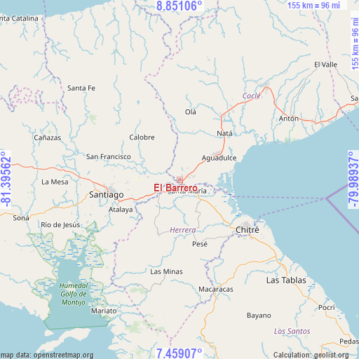
El Barrero GPS coordinates[2]
8° 9' 20.412" North, 80° 41' 32.964" West
| Map corner | latitude | longitude |
|---|---|---|
| Upper-left | 8.85106°, | -81.39562° |
| Center: | 8.15567°, | -80.69249° |
| Lower-right: | 7.45907°, | -79.98937° |
| Map W x H: | 154.8×154.8 km | = 96.2×96.2mi |
| max Lat: | 9.60898° ⇑74.1% North |
| El Barrero: | 8.15567° |
| min Lat: | ⇓25.9% South 7.26534° |
| min Long | El Barrero | max Long |
| -82.91275° | -80.69249° | -77.38965° |
| W 45.6%⇐ | ⇒54.4% E |
Elevation
Elevation of El Barrero is 17 m = 56 ft, and this is 155.1 m = 509 ft below average elevation for this country.
| Max E: |
2103 m = 6900 ft | 85.5% |
| Avg. | 172.1 m = 565 ft | |
| El Barrero | 17 m = 56 ft | |
Min E: |
-1 m = -3 ft | 14.5% |
See also: Panama elevation on elevation.city.
Geographical zone
El Barrero is located in North Torrid zone (between Equator and Tropic of Cancer). Distance of Equator is 906.8 km =563.5 mi to South.| Distance of | km | miles | from El Barrero |
|---|---|---|---|
| North Pole | 9100.2 | 5654.6 | to North |
| Arctic Circle | 6494.3 | 4035.4 | to North |
| Tropic Cancer | 1699.1 | 1055.8 | to North |
| Equator | 906.8 | 563.5 | to South |


Nearby cities:
15 places around El Barrero: (largest is in red/bold)
• Cañazas
3.1 km =1.9 mi,  243°
243°
• Chupampa
12.8 km =8 mi,  226°
226°
• El Cristo
13.2 km =8.2 mi,  36°
36°
• El Limón
14 km =8.7 mi,  219°
219°
• El Pedernal
10 km =6.2 mi,  261°
261°
• El Rincón
9.2 km =5.7 mi,  116°
116°
• El Roble
4 km =2.5 mi,  68°
68°
• La Loma
6.2 km =3.9 mi,  78°
78°
• La Raya de Santa María
14.2 km =8.8 mi,  273°
273°
• Las Guías Abajo
8.1 km =5 mi,  302°
302°
• Llano Sánchez
5 km =3.1 mi,  344°
344°
• Los Canelos
4.6 km =2.9 mi,  201°
201°
• Potuga
12.8 km =8 mi,  143°
143°
• Salitrosa
8.5 km =5.3 mi, 44°
• Santa María
5.7 km =3.5 mi,  149°
149°
Sources, notices
• [Note1] Compared only with cities in Panama existing in our database
• [Src1] Map data: © OpenStreetMap contributors (CC-BY-SA)
• [Src2] Other city data from geonames.org with taken over terms of usage.
• [Src3] Geographical zone / Annual Mean Temperature by Robert A. Rohde @ Wikipedia
