Chupampa geodata
Chupampa (Herrera) is a seat of a third-order administrative division; located in Panama in America/Panama (GMT-5) time zone. With population of 637 people, there are 392 cities with bigger population in this country. Compared to other cities in Panama, 78.1% of cities are located further ↑North; 56.2% of cities are located further →East and 55% of cities have higher elevation than Chupampa. Note1


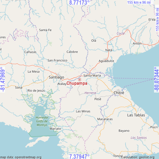
Chupampa GPS coordinates[2]
8° 4' 34.32" North, 80° 46' 35.616" West
| Map corner | latitude | longitude |
|---|---|---|
| Upper-left | 8.77173°, | -81.47969° |
| Center: | 8.0762°, | -80.77656° |
| Lower-right: | 7.37947°, | -80.07344° |
| Map W x H: | 154.8×154.8 km | = 96.2×96.2mi |
| max Lat: | 9.60898° ⇑78.1% North |
| Chupampa: | 8.0762° |
| min Lat: | ⇓21.9% South 7.26534° |
| min Long | Chupampa | max Long |
| -82.91275° | -80.77656° | -77.38965° |
| W 43.8%⇐ | ⇒56.2% E |
Elevation
Elevation of Chupampa is 63 m = 207 ft, and this is 109.1 m = 358 ft below average elevation for this country.
| Max E: |
2103 m = 6900 ft | 55% |
| Avg. | 172.1 m = 565 ft | |
| Chupampa | 63 m = 207 ft | |
Min E: |
-1 m = -3 ft | 45% |
See also: Panama elevation on elevation.city.
Geographical zone
Chupampa is located in North Torrid zone (between Equator and Tropic of Cancer). Distance of Equator is 898 km =558 mi to South.| Distance of | km | miles | from Chupampa |
|---|---|---|---|
| North Pole | 9109.1 | 5660.1 | to North |
| Arctic Circle | 6503.2 | 4040.9 | to North |
| Tropic Cancer | 1707.9 | 1061.2 | to North |
| Equator | 898 | 558 | to South |


Nearby cities:
15 places around Chupampa: (largest is in red/bold)
• Cabuya
10.5 km =6.5 mi,  172°
172°
• Cañazas
9.9 km =6.2 mi,  41°
41°
• El Barrero
12.8 km =8 mi,  46°
46°
• El Espino de Santa Rosa
5.5 km =3.4 mi,  289°
289°
• El Limón
2.1 km =1.3 mi, 168°
• El Pedernal
7.3 km =4.5 mi,  354°
354°
• La Mata
11.4 km =7.1 mi,  277°
277°
• La Montañuela
11.1 km =6.9 mi,  239°
239°
• La Raya de Santa María
11 km =6.8 mi,  333°
333°
• Las Guías Abajo
13.4 km =8.3 mi,  10°
10°
• Llano Grande
13.5 km =8.4 mi,  147°
147°
• Los Boquerones
8.6 km =5.3 mi,  272°
272°
• Los Canelos
8.8 km =5.5 mi,  58°
58°
• Peñas Chatas
7.4 km =4.6 mi,  203°
203°
• Santa María
12.8 km =8 mi,  72°
72°
Sources, notices
• [Note1] Compared only with cities in Panama existing in our database
• [Src1] Map data: © OpenStreetMap contributors (CC-BY-SA)
• [Src2] Other city data from geonames.org with taken over terms of usage.
• [Src3] Geographical zone / Annual Mean Temperature by Robert A. Rohde @ Wikipedia
