Los Canelos geodata
Los Canelos (Herrera) is a seat of a third-order administrative division; located in Panama in America/Panama (GMT-5) time zone. With population of 965 people, there are 267 cities with bigger population in this country. Compared to other cities in Panama, 75.8% of cities are located further ↑North; 54.8% of cities are located further →East and 77.8% of cities have higher elevation than Los Canelos. Note1


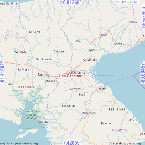
Los Canelos GPS coordinates[2]
8° 7' 1.992" North, 80° 42' 27.684" West
| Map corner | latitude | longitude |
|---|---|---|
| Upper-left | 8.81268°, | -81.41082° |
| Center: | 8.11722°, | -80.70769° |
| Lower-right: | 7.42055°, | -80.00457° |
| Map W x H: | 154.8×154.8 km | = 96.2×96.2mi |
| max Lat: | 9.60898° ⇑75.8% North |
| Los Canelos: | 8.11722° |
| min Lat: | ⇓24.2% South 7.26534° |
| min Long | Los Canelos | max Long |
| -82.91275° | -80.70769° | -77.38965° |
| W 45.2%⇐ | ⇒54.8% E |
Elevation
Elevation of Los Canelos is 26 m = 85 ft, and this is 146.1 m = 479 ft below average elevation for this country.
| Max E: |
2103 m = 6900 ft | 77.8% |
| Avg. | 172.1 m = 565 ft | |
| Los Canelos | 26 m = 85 ft | |
Min E: |
-1 m = -3 ft | 22.2% |
See also: Panama elevation on elevation.city.
Geographical zone
Los Canelos is located in North Torrid zone (between Equator and Tropic of Cancer). Distance of Equator is 902.6 km =560.8 mi to South.| Distance of | km | miles | from Los Canelos |
|---|---|---|---|
| North Pole | 9104.5 | 5657.3 | to North |
| Arctic Circle | 6498.6 | 4038 | to North |
| Tropic Cancer | 1703.4 | 1058.4 | to North |
| Equator | 902.6 | 560.8 | to South |


Nearby cities:
15 places around Los Canelos: (largest is in red/bold)
• Cabuya
12.7 km =7.9 mi,  138°
138°
• Cañazas
3.1 km =1.9 mi,  339°
339°
• Chupampa
8.8 km =5.5 mi,  238°
238°
• El Barrero
4.6 km =2.9 mi,  21°
21°
• El Espino de Santa Rosa
13.1 km =8.1 mi,  258°
258°
• El Limón
9.7 km =6 mi,  227°
227°
• El Pedernal
8.7 km =5.4 mi,  288°
288°
• El Rincón
10 km =6.2 mi,  88°
88°
• El Roble
7.8 km =4.8 mi,  43°
43°
• La Loma
9.5 km =5.9 mi,  54°
54°
• Las Guías Abajo
10 km =6.2 mi,  328°
328°
• Llano Sánchez
9.1 km =5.7 mi,  2°
2°
• Potuga
11.1 km =6.9 mi,  122°
122°
• Salitrosa
12.9 km =8 mi, 36°
• Santa María
4.7 km =2.9 mi,  97°
97°
Sources, notices
• [Note1] Compared only with cities in Panama existing in our database
• [Src1] Map data: © OpenStreetMap contributors (CC-BY-SA)
• [Src2] Other city data from geonames.org with taken over terms of usage.
• [Src3] Geographical zone / Annual Mean Temperature by Robert A. Rohde @ Wikipedia
