El Limón geodata
El Limón (Herrera) is a seat of a third-order administrative division; located in Panama in America/Panama (GMT-5) time zone. In our database, there are 694 cities with bigger population. Compared to other cities in Panama, 78.8% of cities are located further ↑North; 56% of cities are located further →East and 52.4% of cities have higher elevation than El Limón. Note1


El Limón GPS coordinates[2]
8° 3' 28.98" North, 80° 46' 22.404" West
| Map corner | latitude | longitude |
|---|---|---|
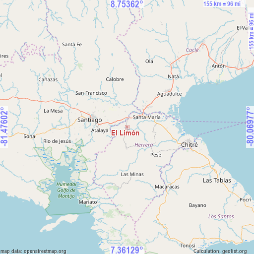
| Upper-left | 8.75362°, | -81.47602° |
| Center: | 8.05805°, | -80.77289° |
| Lower-right: | 7.36129°, | -80.06977° |
| Map W x H: | 154.8×154.8 km | = 96.2×96.2mi |
| max Lat: | 9.60898° ⇑78.8% North |
| El Limón: | 8.05805° |
| min Lat: | ⇓21.2% South 7.26534° |
| min Long | El Limón | max Long |
| -82.91275° | -80.77289° | -77.38965° |
| W 44%⇐ | ⇒56% E |
Elevation
Elevation of El Limón is 68 m = 223 ft, and this is 104.1 m = 342 ft below average elevation for this country.
| Max E: |
2103 m = 6900 ft | 52.4% |
| Avg. | 172.1 m = 565 ft | |
| El Limón | 68 m = 223 ft | |
Min E: |
-1 m = -3 ft | 47.6% |
See also: Panama elevation on elevation.city.
Geographical zone
El Limón is located in North Torrid zone (between Equator and Tropic of Cancer). Distance of Equator is 896 km =556.7 mi to South.| Distance of | km | miles | from El Limón |
|---|---|---|---|
| North Pole | 9111.1 | 5661.4 | to North |
| Arctic Circle | 6505.2 | 4042.1 | to North |
| Tropic Cancer | 1709.9 | 1062.5 | to North |
| Equator | 896 | 556.7 | to South |


Nearby cities:
15 places around El Limón: (largest is in red/bold)
• Cabuya
8.4 km =5.2 mi,  173°
173°
• Cañazas
11.2 km =7 mi,  32°
32°
• Chupampa
2.1 km =1.3 mi,  348°
348°
• El Barrero
14 km =8.7 mi,  39°
39°
• El Espino de Santa Rosa
6.8 km =4.2 mi,  304°
304°
• El Pedernal
9.4 km =5.8 mi, 353°
• La Mata
12.3 km =7.6 mi,  286°
286°
• La Montañuela
10.6 km =6.6 mi,  249°
249°
• La Raya de Santa María
13 km =8.1 mi,  335°
335°
• Llano Grande
11.6 km =7.2 mi,  143°
143°
• Los Boquerones
9.3 km =5.8 mi,  284°
284°
• Los Canelos
9.7 km =6 mi,  47°
47°
• Ocú
13.1 km =8.1 mi,  183°
183°
• Peñas Chatas
5.9 km =3.7 mi,  215°
215°
• Santa María
13.2 km =8.2 mi,  63°
63°
Sources, notices
• [Note1] Compared only with cities in Panama existing in our database
• [Src1] Map data: © OpenStreetMap contributors (CC-BY-SA)
• [Src2] Other city data from geonames.org with taken over terms of usage.
• [Src3] Geographical zone / Annual Mean Temperature by Robert A. Rohde @ Wikipedia
