Cañazas geodata
Cañazas (Veraguas) is a populated place; located in Panama in America/Panama (GMT-5) time zone. With population of 936 people, there are 272 cities with bigger population in this country. Compared to other cities in Panama, 74.6% of cities are located further ↑North; 55% of cities are located further →East and 87.3% of cities have higher elevation than Cañazas. Note1


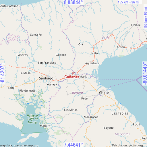
Cañazas GPS coordinates[2]
8° 8' 34.908" North, 80° 43' 3.252" West
| Map corner | latitude | longitude |
|---|---|---|
| Upper-left | 8.83844°, | -81.4207° |
| Center: | 8.14303°, | -80.71757° |
| Lower-right: | 7.44641°, | -80.01445° |
| Map W x H: | 154.8×154.8 km | = 96.2×96.2mi |
| max Lat: | 9.60898° ⇑74.6% North |
| Cañazas: | 8.14303° |
| min Lat: | ⇓25.4% South 7.26534° |
| min Long | Cañazas | max Long |
| -82.91275° | -80.71757° | -77.38965° |
| W 45%⇐ | ⇒55% E |
Elevation
Elevation of Cañazas is 15 m = 49 ft, and this is 157.1 m = 515 ft below average elevation for this country.
| Max E: |
2103 m = 6900 ft | 87.3% |
| Avg. | 172.1 m = 565 ft | |
| Cañazas | 15 m = 49 ft | |
Min E: |
-1 m = -3 ft | 12.7% |
See also: Panama elevation on elevation.city.
Geographical zone
Cañazas is located in North Torrid zone (between Equator and Tropic of Cancer). Distance of Equator is 905.4 km =562.6 mi to South.| Distance of | km | miles | from Cañazas |
|---|---|---|---|
| North Pole | 9101.6 | 5655.5 | to North |
| Arctic Circle | 6495.8 | 4036.3 | to North |
| Tropic Cancer | 1700.5 | 1056.6 | to North |
| Equator | 905.4 | 562.6 | to South |


Nearby cities:
15 places around Cañazas: (largest is in red/bold)
• Chupampa
9.9 km =6.2 mi,  221°
221°
• El Barrero
3.1 km =1.9 mi,  63°
63°
• El Espino de Santa Rosa
13 km =8.1 mi,  244°
244°
• El Limón
11.2 km =7 mi,  212°
212°
• El Pedernal
7.1 km =4.4 mi,  268°
268°
• El Rincón
11.4 km =7.1 mi,  103°
103°
• El Roble
7 km =4.3 mi,  66°
66°
• La Loma
9.2 km =5.7 mi, 73°
• La Raya de Santa María
11.7 km =7.3 mi,  281°
281°
• Las Guías Abajo
7 km =4.3 mi,  324°
324°
• Llano Sánchez
6.4 km =4 mi,  12°
12°
• Los Canelos
3.1 km =1.9 mi,  159°
159°
• Potuga
13.7 km =8.5 mi,  130°
130°
• Salitrosa
11.5 km =7.1 mi,  49°
49°
• Santa María
6.7 km =4.2 mi,  121°
121°
Sources, notices
• [Note1] Compared only with cities in Panama existing in our database
• [Src1] Map data: © OpenStreetMap contributors (CC-BY-SA)
• [Src2] Other city data from geonames.org with taken over terms of usage.
• [Src3] Geographical zone / Annual Mean Temperature by Robert A. Rohde @ Wikipedia
