La Laguna geodata
La Laguna (Panamá Oeste) is a seat of a third-order administrative division; located in Panama in America/Panama (GMT-5) time zone. With population of 253 people, there are 574 cities with bigger population in this country. Compared to other cities in Panama, 64.2% of cities are located further ↓South; 72.2% of cities are located further ←West and 93.8% of cities have lower elevation than La Laguna. Note1


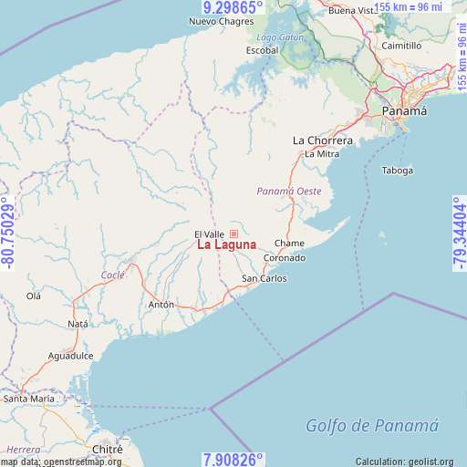
La Laguna GPS coordinates[2]
8° 36' 14.724" North, 80° 2' 49.776" West
| Map corner | latitude | longitude |
|---|---|---|
| Upper-left | 9.29865°, | -80.75029° |
| Center: | 8.60409°, | -80.04716° |
| Lower-right: | 7.90826°, | -79.34404° |
| Map W x H: | 154.6×154.6 km | = 96.1×96.1mi |
| max Lat: | 9.60898° ⇑35.8% North |
| La Laguna: | 8.60409° |
| min Lat: | ⇓64.2% South 7.26534° |
| min Long | La Laguna | max Long |
| -82.91275° | -80.04716° | -77.38965° |
| W 72.2%⇐ | ⇒27.8% E |
Elevation
Elevation of La Laguna is 608 m = 1995 ft, and this is 435.9 m = 1430 ft above average elevation for this country.
| Max E: |
2103 m = 6900 ft | 6.2% |
| La Laguna | 608 m 1995 ft | |
| Avg. | 172.1 m = 565 ft | |
Min E: |
-1 m = -3 ft | 93.8% |
See also: Panama elevation on elevation.city.
Geographical zone
La Laguna is located in North Torrid zone (between Equator and Tropic of Cancer). Distance of Equator is 956.7 km =594.5 mi to South.| Distance of | km | miles | from La Laguna |
|---|---|---|---|
| North Pole | 9050.4 | 5623.7 | to North |
| Arctic Circle | 6444.5 | 4004.4 | to North |
| Tropic Cancer | 1649.2 | 1024.8 | to North |
| Equator | 956.7 | 594.5 | to South |


Nearby cities:
15 places around La Laguna: (largest is in red/bold)
• Alto de La Estancia
15.2 km =9.4 mi,  263°
263°
• Buenos Aires
11.3 km =7 mi,  74°
74°
• Cabuya
13.6 km =8.5 mi,  103°
103°
• Cabuya
14.7 km =9.1 mi,  244°
244°
• El Espino
14.6 km =9.1 mi,  164°
164°
• Guayabito
7.2 km =4.5 mi,  149°
149°
• Las Colinas
7.2 km =4.5 mi,  213°
213°
• Las Lajas
13.7 km =8.5 mi,  116°
116°
• Las Matas
15.8 km =9.8 mi,  198°
198°
• Llano Grande
13 km =8.1 mi,  78°
78°
• Los Llanitos
5.3 km =3.3 mi, 262°
• Mata Ahogado
5.4 km =3.4 mi,  285°
285°
• San José
15.1 km =9.4 mi, 121°
• Sorá
5.2 km =3.2 mi,  53°
53°
• Turega
16.2 km =10.1 mi,  273°
273°
Sources, notices
• [Note1] Compared only with cities in Panama existing in our database
• [Src1] Map data: © OpenStreetMap contributors (CC-BY-SA)
• [Src2] Other city data from geonames.org with taken over terms of usage.
• [Src3] Geographical zone / Annual Mean Temperature by Robert A. Rohde @ Wikipedia
