Cañazas geodata
Cañazas (Veraguas) is a seat of a second-order administrative division; located in Panama in America/Panama (GMT-5) time zone. With population of 3,219 people, there are 91 cities with bigger population in this country. Compared to other cities in Panama, 65.1% of cities are located further ↑North; 65.4% of cities are located further →East and 74.6% of cities have lower elevation than Cañazas. Note1


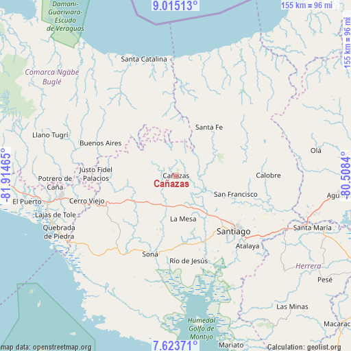
Cañazas GPS coordinates[2]
8° 19' 12.144" North, 81° 12' 41.472" West
| Map corner | latitude | longitude |
|---|---|---|
| Upper-left | 9.01513°, | -81.91465° |
| Center: | 8.32004°, | -81.21152° |
| Lower-right: | 7.62371°, | -80.5084° |
| Map W x H: | 154.7×154.7 km | = 96.1×96.1mi |
| max Lat: | 9.60898° ⇑65.1% North |
| Cañazas: | 8.32004° |
| min Lat: | ⇓34.9% South 7.26534° |
| min Long | Cañazas | max Long |
| -82.91275° | -81.21152° | -77.38965° |
| W 34.6%⇐ | ⇒65.4% E |
Elevation
Elevation of Cañazas is 201 m = 659 ft, and this is 28.9 m = 95 ft above average elevation for this country.
| Max E: |
2103 m = 6900 ft | 25.4% |
| Cañazas | 201 m 659 ft | |
| Avg. | 172.1 m = 565 ft | |
Min E: |
-1 m = -3 ft | 74.6% |
See also: Panama elevation on elevation.city.
Geographical zone
Cañazas is located in North Torrid zone (between Equator and Tropic of Cancer). Distance of Equator is 925.1 km =574.8 mi to South.| Distance of | km | miles | from Cañazas |
|---|---|---|---|
| North Pole | 9082 | 5643.3 | to North |
| Arctic Circle | 6476.1 | 4024.1 | to North |
| Tropic Cancer | 1680.8 | 1044.4 | to North |
| Equator | 925.1 | 574.8 | to South |


Nearby cities:
15 places around Cañazas: (largest is in red/bold)
• Bisvalles
15.3 km =9.5 mi,  183°
183°
• Boró
19.4 km =12.1 mi,  210°
210°
• Calabacito
16.4 km =10.2 mi,  119°
119°
• Cerro de Plata
17.6 km =10.9 mi,  258°
258°
• El Bale
17 km =10.6 mi,  284°
284°
• El Picador
8.1 km =5 mi,  322°
322°
• La Mesa
19.5 km =12.1 mi,  170°
170°
• Los Corotúes
16.2 km =10.1 mi,  46°
46°
• Los Valles
14.4 km =8.9 mi,  5°
5°
• Paredón Arriba
15.6 km =9.7 mi, 6°
• San Bartolo
14.1 km =8.8 mi, 210°
• San José
22.1 km =13.7 mi,  285°
285°
• San Juan
21.6 km =13.4 mi,  94°
94°
• San Marcelo
7.8 km =4.8 mi,  132°
132°
• San Pedro del Espino
24.3 km =15.1 mi,  145°
145°
Sources, notices
• [Note1] Compared only with cities in Panama existing in our database
• [Src1] Map data: © OpenStreetMap contributors (CC-BY-SA)
• [Src2] Other city data from geonames.org with taken over terms of usage.
• [Src3] Geographical zone / Annual Mean Temperature by Robert A. Rohde @ Wikipedia
