San Marcelo geodata
San Marcelo (Veraguas) is a seat of a third-order administrative division; located in Panama in America/Panama (GMT-5) time zone. With population of 66 people, there are 682 cities with bigger population in this country. Compared to other cities in Panama, 68.4% of cities are located further ↑North; 64.4% of cities are located further →East and 67.1% of cities have lower elevation than San Marcelo. Note1


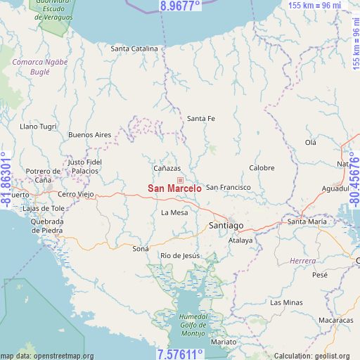
San Marcelo GPS coordinates[2]
8° 16' 21.072" North, 81° 9' 35.568" West
| Map corner | latitude | longitude |
|---|---|---|
| Upper-left | 8.9677°, | -81.86301° |
| Center: | 8.27252°, | -81.15988° |
| Lower-right: | 7.57611°, | -80.45676° |
| Map W x H: | 154.7×154.7 km | = 96.1×96.1mi |
| max Lat: | 9.60898° ⇑68.4% North |
| San Marcelo: | 8.27252° |
| min Lat: | ⇓31.6% South 7.26534° |
| min Long | San Marcelo | max Long |
| -82.91275° | -81.15988° | -77.38965° |
| W 35.6%⇐ | ⇒64.4% E |
Elevation
Elevation of San Marcelo is 136 m = 446 ft, and this is 36.1 m = 118 ft below average elevation for this country.
| Max E: |
2103 m = 6900 ft | 32.9% |
| Avg. | 172.1 m = 565 ft | |
| San Marcelo | 136 m = 446 ft | |
Min E: |
-1 m = -3 ft | 67.1% |
See also: Panama elevation on elevation.city.
Geographical zone
San Marcelo is located in North Torrid zone (between Equator and Tropic of Cancer). Distance of Equator is 919.8 km =571.5 mi to South.| Distance of | km | miles | from San Marcelo |
|---|---|---|---|
| North Pole | 9087.2 | 5646.5 | to North |
| Arctic Circle | 6481.4 | 4027.4 | to North |
| Tropic Cancer | 1686.1 | 1047.7 | to North |
| Equator | 919.8 | 571.5 | to South |


Nearby cities:
15 places around San Marcelo: (largest is in red/bold)
• Bisvalles
12 km =7.5 mi,  214°
214°
• Boró
19.3 km =12 mi,  233°
233°
• Calabacito
9 km =5.6 mi,  107°
107°
• Cañazas
7.8 km =4.8 mi,  312°
312°
• El Picador
15.8 km =9.8 mi,  317°
317°
• La Mesa
14.1 km =8.8 mi,  189°
189°
• La Peña
21.7 km =13.5 mi,  137°
137°
• Los Corotúes
17.5 km =10.9 mi,  20°
20°
• Los Remedios
21 km =13 mi,  134°
134°
• Los Valles
20 km =12.4 mi,  347°
347°
• Paredón Arriba
21.2 km =13.2 mi, 349°
• San Bartolo
14.5 km =9 mi,  241°
241°
• San Francisco
20.6 km =12.8 mi,  98°
98°
• San Juan
16.2 km =10.1 mi,  77°
77°
• San Pedro del Espino
16.8 km =10.4 mi,  151°
151°
Sources, notices
• [Note1] Compared only with cities in Panama existing in our database
• [Src1] Map data: © OpenStreetMap contributors (CC-BY-SA)
• [Src2] Other city data from geonames.org with taken over terms of usage.
• [Src3] Geographical zone / Annual Mean Temperature by Robert A. Rohde @ Wikipedia
