La Mesa geodata
La Mesa (Veraguas) is a seat of a second-order administrative division; located in Panama in America/Panama (GMT-5) time zone. With population of 2,090 people, there are 115 cities with bigger population in this country. Compared to other cities in Panama, 74.4% of cities are located further ↑North; 64.6% of cities are located further →East and 75.7% of cities have lower elevation than La Mesa. Note1


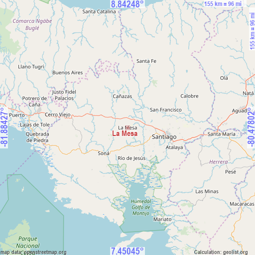
La Mesa GPS coordinates[2]
8° 8' 49.452" North, 81° 10' 52.104" West
| Map corner | latitude | longitude |
|---|---|---|
| Upper-left | 8.84248°, | -81.88427° |
| Center: | 8.14707°, | -81.18114° |
| Lower-right: | 7.45045°, | -80.47802° |
| Map W x H: | 154.8×154.8 km | = 96.2×96.2mi |
| max Lat: | 9.60898° ⇑74.4% North |
| La Mesa: | 8.14707° |
| min Lat: | ⇓25.6% South 7.26534° |
| min Long | La Mesa | max Long |
| -82.91275° | -81.18114° | -77.38965° |
| W 35.4%⇐ | ⇒64.6% E |
Elevation
Elevation of La Mesa is 206 m = 676 ft, and this is 33.9 m = 111 ft above average elevation for this country.
| Max E: |
2103 m = 6900 ft | 24.3% |
| La Mesa | 206 m 676 ft | |
| Avg. | 172.1 m = 565 ft | |
Min E: |
-1 m = -3 ft | 75.7% |
See also: Panama elevation on elevation.city.
Geographical zone
La Mesa is located in North Torrid zone (between Equator and Tropic of Cancer). Distance of Equator is 905.9 km =562.9 mi to South.| Distance of | km | miles | from La Mesa |
|---|---|---|---|
| North Pole | 9101.2 | 5655.2 | to North |
| Arctic Circle | 6495.3 | 4036 | to North |
| Tropic Cancer | 1700 | 1056.3 | to North |
| Equator | 905.9 | 562.9 | to South |


Nearby cities:
15 places around La Mesa: (largest is in red/bold)
• Bisvalles
5.9 km =3.7 mi,  312°
312°
• Boró
13.4 km =8.3 mi,  280°
280°
• Calabacito
15.7 km =9.8 mi,  44°
44°
• Cañazas
19.5 km =12.1 mi,  350°
350°
• El Marañón
12.9 km =8 mi,  196°
196°
• La Peña
17.1 km =10.6 mi,  97°
97°
• Llano Grande
9.4 km =5.8 mi,  148°
148°
• Los Algarrobos
18.9 km =11.7 mi, 102°
• Los Castillos
15.4 km =9.6 mi, 153°
• Los Remedios
17.3 km =10.7 mi,  92°
92°
• Rodeo Viejo
15.4 km =9.6 mi,  255°
255°
• Río de Jesús
18.8 km =11.7 mi,  173°
173°
• San Bartolo
12.6 km =7.8 mi,  304°
304°
• San Marcelo
14.1 km =8.8 mi,  9°
9°
• San Pedro del Espino
10.4 km =6.5 mi, 94°
Sources, notices
• [Note1] Compared only with cities in Panama existing in our database
• [Src1] Map data: © OpenStreetMap contributors (CC-BY-SA)
• [Src2] Other city data from geonames.org with taken over terms of usage.
• [Src3] Geographical zone / Annual Mean Temperature by Robert A. Rohde @ Wikipedia
