Camogantí geodata
Camogantí (Darién) is a seat of a third-order administrative division; located in Panama in America/Panama (GMT-5) time zone. With population of 179 people, there are 614 cities with bigger population in this country. Compared to other cities in Panama, 79.3% of cities are located further ↑North; 98% of cities are located further ←West and 93.8% of cities have higher elevation than Camogantí. Note1


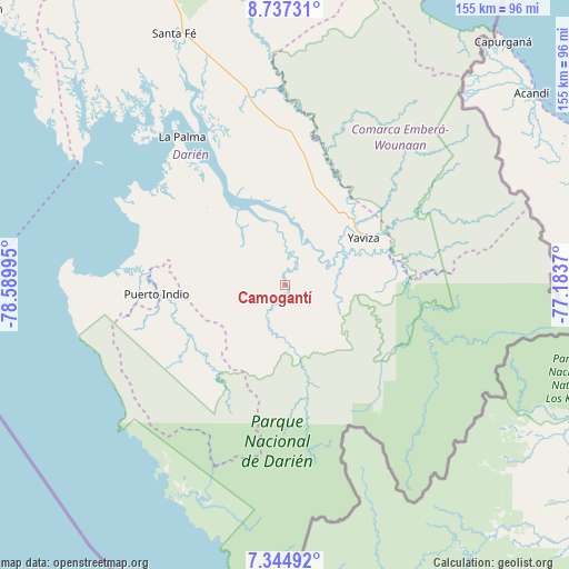
Camogantí GPS coordinates[2]
8° 2' 30.156" North, 77° 53' 12.552" West
| Map corner | latitude | longitude |
|---|---|---|
| Upper-left | 8.73731°, | -78.58995° |
| Center: | 8.04171°, | -77.88682° |
| Lower-right: | 7.34492°, | -77.1837° |
| Map W x H: | 154.8×154.8 km | = 96.2×96.2mi |
| max Lat: | 9.60898° ⇑79.3% North |
| Camogantí: | 8.04171° |
| min Lat: | ⇓20.7% South 7.26534° |
| min Long | Camogantí | max Long |
| -82.91275° | -77.88682° | -77.38965° |
| W 98%⇐ | ⇒2% E |
Elevation
Elevation of Camogantí is 9 m = 30 ft, and this is 163.1 m = 535 ft below average elevation for this country.
| Max E: |
2103 m = 6900 ft | 93.8% |
| Avg. | 172.1 m = 565 ft | |
| Camogantí | 9 m = 30 ft | |
Min E: |
-1 m = -3 ft | 6.2% |
See also: Panama elevation on elevation.city.
Geographical zone
Camogantí is located in North Torrid zone (between Equator and Tropic of Cancer). Distance of Equator is 894.2 km =555.6 mi to South.| Distance of | km | miles | from Camogantí |
|---|---|---|---|
| North Pole | 9112.9 | 5662.5 | to North |
| Arctic Circle | 6507 | 4043.3 | to North |
| Tropic Cancer | 1711.8 | 1063.7 | to North |
| Equator | 894.2 | 555.6 | to South |


Nearby cities:
15 places around Camogantí: (largest is in red/bold)
• Bayamón
37.2 km =23.1 mi,  257°
257°
• Boca de Cupé
32.7 km =20.3 mi,  92°
92°
• Chepigana
32.7 km =20.3 mi,  326°
326°
• Corozal
36.6 km =22.7 mi,  61°
61°
• El Real de Santa María
21.8 km =13.5 mi, 63°
• Jingurudó
27.6 km =17.1 mi,  229°
229°
• Pinogana
23.2 km =14.4 mi,  70°
70°
• Pueblo Nuevo
24.4 km =15.2 mi, 60°
• Puerto Indio
35.1 km =21.8 mi,  266°
266°
• Sambú
35.5 km =22.1 mi, 267°
• Setegantí
36.6 km =22.7 mi,  320°
320°
• Tucutí
14.2 km =8.8 mi,  207°
207°
• Unión Chocó
39 km =24.2 mi,  83°
83°
• Yape
32.4 km =20.1 mi, 78°
• Yaviza
25 km =15.5 mi, 58°
Sources, notices
• [Note1] Compared only with cities in Panama existing in our database
• [Src1] Map data: © OpenStreetMap contributors (CC-BY-SA)
• [Src2] Other city data from geonames.org with taken over terms of usage.
• [Src3] Geographical zone / Annual Mean Temperature by Robert A. Rohde @ Wikipedia
