Unión Chocó geodata
Unión Chocó (Emberá) is a seat of a first-order administrative division; located in Panama in America/Panama (GMT-5) time zone. With population of 9,497 people, there are 41 cities with bigger population in this country. Compared to other cities in Panama, 77.7% of cities are located further ↑North; 99.5% of cities are located further ←West and 56.3% of cities have higher elevation than Unión Chocó. Note1


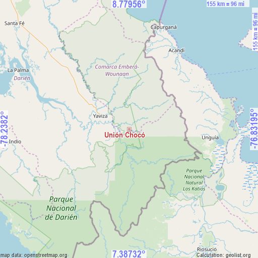
Unión Chocó GPS coordinates[2]
8° 5' 2.544" North, 77° 32' 6.252" West
| Map corner | latitude | longitude |
|---|---|---|
| Upper-left | 8.77956°, | -78.2382° |
| Center: | 8.08404°, | -77.53507° |
| Lower-right: | 7.38732°, | -76.83195° |
| Map W x H: | 154.8×154.8 km | = 96.2×96.2mi |
| max Lat: | 9.60898° ⇑77.7% North |
| Unión Chocó: | 8.08404° |
| min Lat: | ⇓22.3% South 7.26534° |
| min Long | Unión Chocó | max Long |
| -82.91275° | -77.53507° | -77.38965° |
| W 99.5%⇐ | ⇒0.5% E |
Elevation
Elevation of Unión Chocó is 61 m = 200 ft, and this is 111.1 m = 365 ft below average elevation for this country.
| Max E: |
2103 m = 6900 ft | 56.3% |
| Avg. | 172.1 m = 565 ft | |
| Unión Chocó | 61 m = 200 ft | |
Min E: |
-1 m = -3 ft | 43.7% |
See also: Panama elevation on elevation.city.
Geographical zone
Unión Chocó is located in North Torrid zone (between Equator and Tropic of Cancer). Distance of Equator is 898.9 km =558.6 mi to South.| Distance of | km | miles | from Unión Chocó |
|---|---|---|---|
| North Pole | 9108.2 | 5659.6 | to North |
| Arctic Circle | 6502.3 | 4040.3 | to North |
| Tropic Cancer | 1707.1 | 1060.7 | to North |
| Equator | 898.9 | 558.6 | to South |


Nearby cities:
15 places around Unión Chocó: (largest is in red/bold)
• Armila
65 km =40.4 mi,  8°
8°
• Boca de Cupé
8.5 km =5.3 mi,  225°
225°
• Camogantí
39 km =24.2 mi,  263°
263°
• Chepigana
61.2 km =38 mi,  291°
291°
• Corozal
14.7 km =9.1 mi,  332°
332°
• El Real de Santa María
19.9 km =12.4 mi,  284°
284°
• Jingurudó
63.8 km =39.6 mi,  249°
249°
• Lajas Blancas
47.7 km =29.6 mi,  320°
320°
• Paya
25.9 km =16.1 mi,  141°
141°
• Pinogana
17.2 km =10.7 mi, 280°
• Pueblo Nuevo
18.9 km =11.7 mi, 292°
• Púcuro
12.8 km =8 mi,  155°
155°
• Tucutí
48.4 km =30.1 mi, 248°
• Yape
7.1 km =4.4 mi, 282°
• Yaviza
19.2 km =11.9 mi,  295°
295°
Sources, notices
• [Note1] Compared only with cities in Panama existing in our database
• [Src1] Map data: © OpenStreetMap contributors (CC-BY-SA)
• [Src2] Other city data from geonames.org with taken over terms of usage.
• [Src3] Geographical zone / Annual Mean Temperature by Robert A. Rohde @ Wikipedia
