Yaviza geodata
Yaviza (Darién) is a seat of a third-order administrative division; located in Panama in America/Panama (GMT-5) time zone. With population of 1,700 people, there are 140 cities with bigger population in this country. Compared to other cities in Panama, 73.9% of cities are located further ↑North; 98.7% of cities are located further ←West and 92.8% of cities have higher elevation than Yaviza. Note1


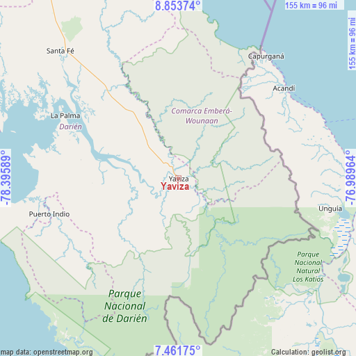
Yaviza GPS coordinates[2]
8° 9' 30.06" North, 77° 41' 33.936" West
| Map corner | latitude | longitude |
|---|---|---|
| Upper-left | 8.85374°, | -78.39589° |
| Center: | 8.15835°, | -77.69276° |
| Lower-right: | 7.46175°, | -76.98964° |
| Map W x H: | 154.8×154.8 km | = 96.2×96.2mi |
| max Lat: | 9.60898° ⇑73.9% North |
| Yaviza: | 8.15835° |
| min Lat: | ⇓26.1% South 7.26534° |
| min Long | Yaviza | max Long |
| -82.91275° | -77.69276° | -77.38965° |
| W 98.7%⇐ | ⇒1.3% E |
Elevation
Elevation of Yaviza is 10 m = 33 ft, and this is 162.1 m = 532 ft below average elevation for this country.
| Max E: |
2103 m = 6900 ft | 92.8% |
| Avg. | 172.1 m = 565 ft | |
| Yaviza | 10 m = 33 ft | |
Min E: |
-1 m = -3 ft | 7.2% |
See also: Panama elevation on elevation.city.
Geographical zone
Yaviza is located in North Torrid zone (between Equator and Tropic of Cancer). Distance of Equator is 907.1 km =563.6 mi to South.| Distance of | km | miles | from Yaviza |
|---|---|---|---|
| North Pole | 9099.9 | 5654.4 | to North |
| Arctic Circle | 6494.1 | 4035.2 | to North |
| Tropic Cancer | 1698.8 | 1055.6 | to North |
| Equator | 907.1 | 563.6 | to South |


Nearby cities:
15 places around Yaviza: (largest is in red/bold)
• Boca de Cupé
18.2 km =11.3 mi,  141°
141°
• Camogantí
25 km =15.5 mi,  238°
238°
• Chepigana
42 km =26.1 mi,  289°
289°
• Corozal
11.6 km =7.2 mi,  65°
65°
• El Real de Santa María
3.7 km =2.3 mi,  211°
211°
• Lajas Blancas
31.4 km =19.5 mi,  335°
335°
• Metetí
49.3 km =30.6 mi,  320°
320°
• Paya
44 km =27.3 mi,  130°
130°
• Pinogana
5.1 km =3.2 mi,  174°
174°
• Pueblo Nuevo
1 km =0.6 mi,  187°
187°
• Púcuro
30.1 km =18.7 mi, 131°
• Setegantí
47.3 km =29.4 mi, 288°
• Tucutí
37.8 km =23.5 mi,  227°
227°
• Unión Chocó
19.2 km =11.9 mi,  115°
115°
• Yape
12.4 km =7.7 mi, 122°
Sources, notices
• [Note1] Compared only with cities in Panama existing in our database
• [Src1] Map data: © OpenStreetMap contributors (CC-BY-SA)
• [Src2] Other city data from geonames.org with taken over terms of usage.
• [Src3] Geographical zone / Annual Mean Temperature by Robert A. Rohde @ Wikipedia
