Chepigana geodata
Chepigana (Darién) is a seat of a third-order administrative division; located in Panama in America/Panama (GMT-5) time zone. In our database, there are 694 cities with bigger population. Compared to other cities in Panama, 67.6% of cities are located further ↑North; 96.9% of cities are located further ←West and 51.4% of cities have lower elevation than Chepigana. Note1


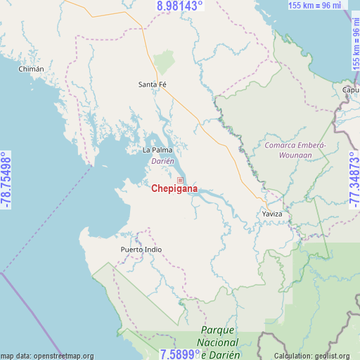
Chepigana GPS coordinates[2]
8° 17' 10.608" North, 78° 3' 6.66" West
| Map corner | latitude | longitude |
|---|---|---|
| Upper-left | 8.98143°, | -78.75498° |
| Center: | 8.28628°, | -78.05185° |
| Lower-right: | 7.5899°, | -77.34873° |
| Map W x H: | 154.7×154.7 km | = 96.1×96.1mi |
| max Lat: | 9.60898° ⇑67.6% North |
| Chepigana: | 8.28628° |
| min Lat: | ⇓32.4% South 7.26534° |
| min Long | Chepigana | max Long |
| -82.91275° | -78.05185° | -77.38965° |
| W 96.9%⇐ | ⇒3.1% E |
Elevation
Elevation of Chepigana is 76 m = 249 ft, and this is 96.1 m = 315 ft below average elevation for this country.
| Max E: |
2103 m = 6900 ft | 48.6% |
| Avg. | 172.1 m = 565 ft | |
| Chepigana | 76 m = 249 ft | |
Min E: |
-1 m = -3 ft | 51.4% |
See also: Panama elevation on elevation.city.
Geographical zone
Chepigana is located in North Torrid zone (between Equator and Tropic of Cancer). Distance of Equator is 921.3 km =572.5 mi to South.| Distance of | km | miles | from Chepigana |
|---|---|---|---|
| North Pole | 9085.7 | 5645.6 | to North |
| Arctic Circle | 6479.8 | 4026.4 | to North |
| Tropic Cancer | 1684.6 | 1046.8 | to North |
| Equator | 921.3 | 572.5 | to South |


Nearby cities:
15 places around Chepigana: (largest is in red/bold)
• Bayamón
39.7 km =24.7 mi,  207°
207°
• Camogantí
32.7 km =20.3 mi,  146°
146°
• Cucunatí
39.2 km =24.4 mi,  324°
324°
• El Real de Santa María
41.4 km =25.7 mi,  114°
114°
• La Palma
16.5 km =10.3 mi, 324°
• Lajas Blancas
30 km =18.6 mi,  61°
61°
• Metetí
25 km =15.5 mi,  18°
18°
• Pueblo Nuevo
26.6 km =16.5 mi,  235°
235°
• Puerto Indio
33.9 km =21.1 mi, 209°
• Punta Alegre
22.3 km =13.9 mi,  272°
272°
• Quebrada Honda
39.4 km =24.5 mi,  350°
350°
• Sambú
33.8 km =21 mi, 210°
• Setegantí
5.4 km =3.4 mi,  278°
278°
• Villa Darién
29.2 km =18.1 mi,  9°
9°
• Zapallal
41.3 km =25.7 mi, 347°
Sources, notices
• [Note1] Compared only with cities in Panama existing in our database
• [Src1] Map data: © OpenStreetMap contributors (CC-BY-SA)
• [Src2] Other city data from geonames.org with taken over terms of usage.
• [Src3] Geographical zone / Annual Mean Temperature by Robert A. Rohde @ Wikipedia
