Corozal geodata
Corozal (Emberá) is a seat of a third-order administrative division; located in Panama in America/Panama (GMT-5) time zone. With population of 309 people, there are 556 cities with bigger population in this country. Compared to other cities in Panama, 72.4% of cities are located further ↑North; 99.2% of cities are located further ←West and 78.5% of cities have higher elevation than Corozal. Note1


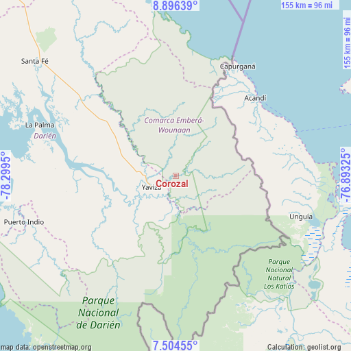
Corozal GPS coordinates[2]
8° 12' 3.888" North, 77° 35' 46.932" West
| Map corner | latitude | longitude |
|---|---|---|
| Upper-left | 8.89639°, | -78.2995° |
| Center: | 8.20108°, | -77.59637° |
| Lower-right: | 7.50455°, | -76.89325° |
| Map W x H: | 154.8×154.8 km | = 96.2×96.2mi |
| max Lat: | 9.60898° ⇑72.4% North |
| Corozal: | 8.20108° |
| min Lat: | ⇓27.6% South 7.26534° |
| min Long | Corozal | max Long |
| -82.91275° | -77.59637° | -77.38965° |
| W 99.2%⇐ | ⇒0.8% E |
Elevation
Elevation of Corozal is 25 m = 82 ft, and this is 147.1 m = 483 ft below average elevation for this country.
| Max E: |
2103 m = 6900 ft | 78.5% |
| Avg. | 172.1 m = 565 ft | |
| Corozal | 25 m = 82 ft | |
Min E: |
-1 m = -3 ft | 21.5% |
See also: Panama elevation on elevation.city.
Geographical zone
Corozal is located in North Torrid zone (between Equator and Tropic of Cancer). Distance of Equator is 911.9 km =566.6 mi to South.| Distance of | km | miles | from Corozal |
|---|---|---|---|
| North Pole | 9095.2 | 5651.5 | to North |
| Arctic Circle | 6489.3 | 4032.3 | to North |
| Tropic Cancer | 1694 | 1052.6 | to North |
| Equator | 911.9 | 566.6 | to South |


Nearby cities:
15 places around Corozal: (largest is in red/bold)
• Armila
53.7 km =33.4 mi,  17°
17°
• Boca de Cupé
19 km =11.8 mi,  177°
177°
• Camogantí
36.6 km =22.7 mi,  241°
241°
• Chepigana
51 km =31.7 mi,  280°
280°
• El Real de Santa María
14.8 km =9.2 mi, 237°
• Lajas Blancas
33.6 km =20.9 mi,  315°
315°
• Metetí
53.6 km =33.3 mi,  308°
308°
• Paya
40.4 km =25.1 mi,  145°
145°
• Pinogana
14.1 km =8.8 mi,  226°
226°
• Pueblo Nuevo
12.2 km =7.6 mi, 241°
• Púcuro
27.5 km =17.1 mi, 154°
• Tucutí
49 km =30.4 mi, 231°
• Unión Chocó
14.7 km =9.1 mi, 152°
• Yape
11.4 km =7.1 mi, 180°
• Yaviza
11.6 km =7.2 mi,  245°
245°
Sources, notices
• [Note1] Compared only with cities in Panama existing in our database
• [Src1] Map data: © OpenStreetMap contributors (CC-BY-SA)
• [Src2] Other city data from geonames.org with taken over terms of usage.
• [Src3] Geographical zone / Annual Mean Temperature by Robert A. Rohde @ Wikipedia
