Bayamón geodata
Bayamón (Emberá) is a seat of a third-order administrative division; located in Panama in America/Panama (GMT-5) time zone. With population of 457 people, there are 497 cities with bigger population in this country. Compared to other cities in Panama, 83.1% of cities are located further ↑North; 95.1% of cities are located further ←West and 77% of cities have higher elevation than Bayamón. Note1


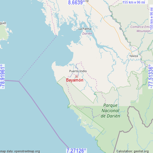
Bayamón GPS coordinates[2]
7° 58' 5.412" North, 78° 12' 59.328" West
| Map corner | latitude | longitude |
|---|---|---|
| Upper-left | 8.6639°, | -78.91961° |
| Center: | 7.96817°, | -78.21648° |
| Lower-right: | 7.27126°, | -77.51336° |
| Map W x H: | 154.8×154.9 km | = 96.2×96.3mi |
| max Lat: | 9.60898° ⇑83.1% North |
| Bayamón: | 7.96817° |
| min Lat: | ⇓16.9% South 7.26534° |
| min Long | Bayamón | max Long |
| -82.91275° | -78.21648° | -77.38965° |
| W 95.1%⇐ | ⇒4.9% E |
Elevation
Elevation of Bayamón is 28 m = 92 ft, and this is 144.1 m = 473 ft below average elevation for this country.
| Max E: |
2103 m = 6900 ft | 77% |
| Avg. | 172.1 m = 565 ft | |
| Bayamón | 28 m = 92 ft | |
Min E: |
-1 m = -3 ft | 23% |
See also: Panama elevation on elevation.city.
Geographical zone
Bayamón is located in North Torrid zone (between Equator and Tropic of Cancer). Distance of Equator is 886 km =550.5 mi to South.| Distance of | km | miles | from Bayamón |
|---|---|---|---|
| North Pole | 9121.1 | 5667.6 | to North |
| Arctic Circle | 6515.2 | 4048.4 | to North |
| Tropic Cancer | 1719.9 | 1068.7 | to North |
| Equator | 886 | 550.5 | to South |


Nearby cities:
15 places around Bayamón: (largest is in red/bold)
• Camogantí
37.2 km =23.1 mi,  77°
77°
• Chepigana
39.7 km =24.7 mi,  27°
27°
• El Real de Santa María
58.6 km =36.4 mi,  72°
72°
• Garachiné
19.6 km =12.2 mi,  303°
303°
• Gonzalo Vásquez
56.2 km =34.9 mi,  332°
332°
• Jaqué
50.4 km =31.3 mi,  173°
173°
• Jingurudó
18.3 km =11.4 mi,  122°
122°
• La Palma
49.4 km =30.7 mi,  9°
9°
• Pueblo Nuevo
20.6 km =12.8 mi,  349°
349°
• Puerto Indio
6.1 km =3.8 mi, 11°
• Puerto Piña
43 km =26.7 mi, 174°
• Punta Alegre
36.6 km =22.7 mi, 353°
• Sambú
6.4 km =4 mi, 7°
• Setegantí
38.4 km =23.9 mi,  19°
19°
• Tucutí
30.2 km =18.8 mi,  98°
98°
Sources, notices
• [Note1] Compared only with cities in Panama existing in our database
• [Src1] Map data: © OpenStreetMap contributors (CC-BY-SA)
• [Src2] Other city data from geonames.org with taken over terms of usage.
• [Src3] Geographical zone / Annual Mean Temperature by Robert A. Rohde @ Wikipedia
