Virú geodata
Virú (La Libertad) is a populated place; located in Peru in America/Lima (GMT-5) time zone. With population of 20,774 people, there are 83 cities with bigger population in this country. Compared to other cities in Peru, 71.4% of cities are located further ↓South; 88.1% of cities are located further →East and 91.2% of cities have higher elevation than Virú. Note1


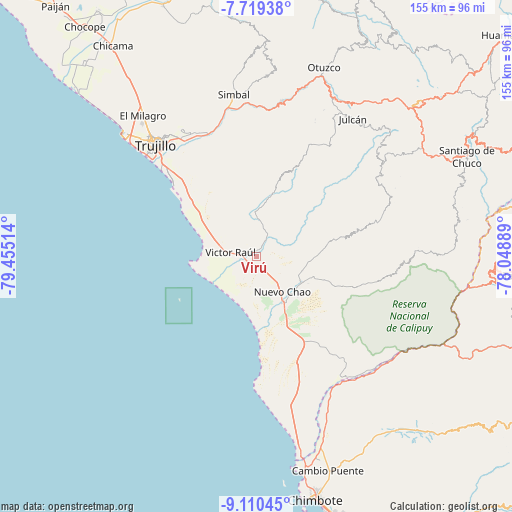
Virú GPS coordinates[2]
8° 24' 55.944" South, 78° 45' 7.236" West
| Map corner | latitude | longitude |
|---|---|---|
| Upper-left | -7.71938°, | -79.45514° |
| Center: | -8.41554°, | -78.75201° |
| Lower-right: | -9.11045°, | -78.04889° |
| Map W x H: | 154.7×154.7 km | = 96.1×96.1mi |
| max Lat: | -0.96667° ⇑28.6% North |
| Virú: | -8.41554° |
| min Lat: | ⇓71.4% South -18.01465° |
| min Long | Virú | max Long |
| -81.30472° | -78.75201° | -69.04167° |
| W 11.9%⇐ | ⇒88.1% E |
Elevation
Elevation of Virú is 75 m = 246 ft, and this is 2243.7 m = 7361 ft below average elevation for this country.
| Max E: |
5022 m = 16476 ft | 91.2% |
| Avg. | 2318.7 m = 7607 ft | |
| Virú | 75 m = 246 ft | |
Min E: |
1 m = 3 ft | 8.8% |
See also: Peru elevation on elevation.city.
Geographical zone
Virú is located in South Torrid zone (between Equator and Tropic of Capricorn). Distance of Equator is 935.7 km =581.4 mi to North.| Distance of | km | miles | from Virú |
|---|---|---|---|
| Equator | 935.7 | 581.4 | to North |
| Tropic Capricorn | 1670.2 | 1037.8 | to South |
| Antarctic Circle | 6465.5 | 4017.5 | to South |
| South Pole | 9071.3 | 5636.6 | to South |


Nearby cities:
15 places around Virú: (largest is in red/bold)
• Agallpampa
53 km =32.9 mi,  24°
24°
• Buenos Aires
44.2 km =27.5 mi,  314°
314°
• Carabamba
36.4 km =22.6 mi, 24°
• Chao
16.3 km =10.1 mi,  150°
150°
• El Porvenir
45.9 km =28.5 mi,  323°
323°
• Huanchaco
54.5 km =33.9 mi, 312°
• La Esperanza
49.5 km =30.8 mi, 319°
• Laredo
42.9 km =26.7 mi,  327°
327°
• Mache
48.8 km =30.3 mi,  29°
29°
• Moche
39.2 km =24.4 mi, 313°
• Poroto
45 km =28 mi,  357°
357°
• Salaverry
32.9 km =20.4 mi, 311°
• Salpo
48.5 km =30.1 mi, 17°
• Simbal
49.3 km =30.6 mi,  352°
352°
• Trujillo
45.2 km =28.1 mi, 317°
Sources, notices
• [Note1] Compared only with cities in Peru existing in our database
• [Src1] Map data: © OpenStreetMap contributors (CC-BY-SA)
• [Src2] Other city data from geonames.org with taken over terms of usage.
• [Src3] Geographical zone / Annual Mean Temperature by Robert A. Rohde @ Wikipedia
