Huanchaco geodata
Huanchaco (La Libertad) is a seat of a third-order administrative division; located in Peru in America/Lima (GMT-5) time zone. In our database, there are 305 cities with bigger population. Compared to other cities in Peru, 73.5% of cities are located further ↓South; 91% of cities are located further →East and 97.4% of cities have higher elevation than Huanchaco. Note1


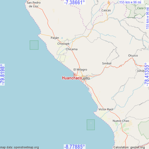
Huanchaco GPS coordinates[2]
8° 4' 59.988" South, 79° 7' 0.012" West
| Map corner | latitude | longitude |
|---|---|---|
| Upper-left | -7.38661°, | -79.8198° |
| Center: | -8.08333°, | -79.11667° |
| Lower-right: | -8.77885°, | -78.41355° |
| Map W x H: | 154.8×154.8 km | = 96.2×96.2mi |
| max Lat: | -0.96667° ⇑26.5% North |
| Huanchaco: | -8.08333° |
| min Lat: | ⇓73.5% South -18.01465° |
| min Long | Huanchaco | max Long |
| -81.30472° | -79.11667° | -69.04167° |
| W 9%⇐ | ⇒91% E |
Elevation
Elevation of Huanchaco is 15 m = 49 ft, and this is 2303.7 m = 7558 ft below average elevation for this country.
| Max E: |
5022 m = 16476 ft | 97.4% |
| Avg. | 2318.7 m = 7607 ft | |
| Huanchaco | 15 m = 49 ft | |
Min E: |
1 m = 3 ft | 2.6% |
See also: Peru elevation on elevation.city.
Geographical zone
Huanchaco is located in South Torrid zone (between Equator and Tropic of Capricorn). Distance of Equator is 898.8 km =558.5 mi to North.| Distance of | km | miles | from Huanchaco |
|---|---|---|---|
| Equator | 898.8 | 558.5 | to North |
| Tropic Capricorn | 1707.1 | 1060.7 | to South |
| Antarctic Circle | 6502.4 | 4040.4 | to South |
| South Pole | 9108.3 | 5659.6 | to South |


Nearby cities:
15 places around Huanchaco: (largest is in red/bold)
• Ascope
41 km =25.5 mi,  1°
1°
• Buenos Aires
10.4 km =6.5 mi,  126°
126°
• Casa Grande
38.5 km =23.9 mi,  348°
348°
• Chicama
26.7 km =16.6 mi, 352°
• Chocope
34.5 km =21.4 mi,  340°
340°
• El Porvenir
12.8 km =8 mi,  90°
90°
• La Esperanza
8.1 km =5 mi,  84°
84°
• Laredo
17.2 km =10.7 mi, 92°
• Moche
15.3 km =9.5 mi, 129°
• Paiján
44 km =27.3 mi,  332°
332°
• Poroto
39.2 km =24.4 mi, 78°
• Salaverry
21.7 km =13.5 mi, 134°
• Santiago de Cao
19.3 km =12 mi,  315°
315°
• Simbal
35.4 km =22 mi,  70°
70°
• Trujillo
10.2 km =6.3 mi,  110°
110°
Sources, notices
• [Note1] Compared only with cities in Peru existing in our database
• [Src1] Map data: © OpenStreetMap contributors (CC-BY-SA)
• [Src2] Other city data from geonames.org with taken over terms of usage.
• [Src3] Geographical zone / Annual Mean Temperature by Robert A. Rohde @ Wikipedia
