Chao geodata
Chao (La Libertad) is a seat of a third-order administrative division; located in Peru in America/Lima (GMT-5) time zone. In our database, there are 305 cities with bigger population. Compared to other cities in Peru, 70.7% of cities are located further ↓South; 87.5% of cities are located further →East and 90.7% of cities have higher elevation than Chao. Note1


Chao GPS coordinates[2]
8° 32' 35.016" South, 78° 40' 45.012" West
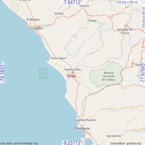
| Map corner | latitude | longitude |
|---|---|---|
| Upper-left | -7.84712°, | -79.3823° |
| Center: | -8.54306°, | -78.67917° |
| Lower-right: | -9.23773°, | -77.97605° |
| Map W x H: | 154.6×154.6 km | = 96.1×96.1mi |
| max Lat: | -0.96667° ⇑29.3% North |
| Chao: | -8.54306° |
| min Lat: | ⇓70.7% South -18.01465° |
| min Long | Chao | max Long |
| -81.30472° | -78.67917° | -69.04167° |
| W 12.5%⇐ | ⇒87.5% E |
Elevation
Elevation of Chao is 81 m = 266 ft, and this is 2237.7 m = 7342 ft below average elevation for this country.
| Max E: |
5022 m = 16476 ft | 90.7% |
| Avg. | 2318.7 m = 7607 ft | |
| Chao | 81 m = 266 ft | |
Min E: |
1 m = 3 ft | 9.3% |
See also: Peru elevation on elevation.city.
Geographical zone
Chao is located in South Torrid zone (between Equator and Tropic of Capricorn). Distance of Equator is 949.9 km =590.2 mi to North.| Distance of | km | miles | from Chao |
|---|---|---|---|
| Equator | 949.9 | 590.2 | to North |
| Tropic Capricorn | 1656 | 1029 | to South |
| Antarctic Circle | 6451.3 | 4008.7 | to South |
| South Pole | 9057.2 | 5627.9 | to South |


Nearby cities:
15 places around Chao: (largest is in red/bold)
• Buenos Aires
60 km =37.3 mi,  318°
318°
• Carabamba
47.9 km =29.8 mi,  8°
8°
• Chimbote
61.3 km =38.1 mi,  169°
169°
• Coishco
53.8 km =33.4 mi, 172°
• Guadalupito
45.7 km =28.4 mi, 172°
• Laredo
59.1 km =36.7 mi,  328°
328°
• Mache
58.9 km =36.6 mi,  15°
15°
• Moche
55 km =34.2 mi, 318°
• Poroto
59.9 km =37.2 mi,  350°
350°
• Puerto Santa
49.6 km =30.8 mi,  175°
175°
• Salaverry
48.5 km =30.1 mi, 317°
• Salpo
60.8 km =37.8 mi, 6°
• Santa
50.1 km =31.1 mi, 171°
• Trujillo
61.2 km =38 mi, 320°
• Virú
16.3 km =10.1 mi, 330°
Sources, notices
• [Note1] Compared only with cities in Peru existing in our database
• [Src1] Map data: © OpenStreetMap contributors (CC-BY-SA)
• [Src2] Other city data from geonames.org with taken over terms of usage.
• [Src3] Geographical zone / Annual Mean Temperature by Robert A. Rohde @ Wikipedia
