Ascope geodata
Ascope (La Libertad) is a seat of a third-order administrative division; located in Peru in America/Lima (GMT-5) time zone. With population of 14,015 people, there are 116 cities with bigger population in this country. Compared to other cities in Peru, 75.5% of cities are located further ↓South; 90.9% of cities are located further →East and 83.2% of cities have higher elevation than Ascope. Note1


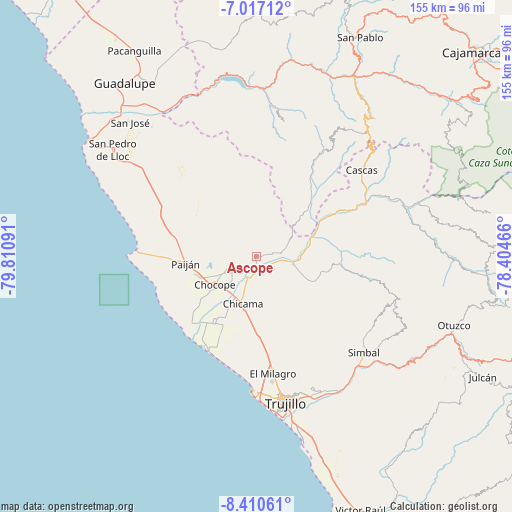
Ascope GPS coordinates[2]
7° 42' 51.984" South, 79° 6' 28.008" West
| Map corner | latitude | longitude |
|---|---|---|
| Upper-left | -7.01712°, | -79.81091° |
| Center: | -7.71444°, | -79.10778° |
| Lower-right: | -8.41061°, | -78.40466° |
| Map W x H: | 154.9×154.9 km | = 96.3×96.3mi |
| max Lat: | -0.96667° ⇑24.5% North |
| Ascope: | -7.71444° |
| min Lat: | ⇓75.5% South -18.01465° |
| min Long | Ascope | max Long |
| -81.30472° | -79.10778° | -69.04167° |
| W 9.1%⇐ | ⇒90.9% E |
Elevation
Elevation of Ascope is 231 m = 758 ft, and this is 2087.7 m = 6849 ft below average elevation for this country.
| Max E: |
5022 m = 16476 ft | 83.2% |
| Avg. | 2318.7 m = 7607 ft | |
| Ascope | 231 m = 758 ft | |
Min E: |
1 m = 3 ft | 16.8% |
See also: Peru elevation on elevation.city.
Geographical zone
Ascope is located in South Torrid zone (between Equator and Tropic of Capricorn). Distance of Equator is 857.8 km =533 mi to North.| Distance of | km | miles | from Ascope |
|---|---|---|---|
| Equator | 857.8 | 533 | to North |
| Tropic Capricorn | 1748.2 | 1086.3 | to South |
| Antarctic Circle | 6543.4 | 4065.9 | to South |
| South Pole | 9149.3 | 5685.1 | to South |


Nearby cities:
15 places around Ascope: (largest is in red/bold)
• Casa Grande
9.3 km =5.8 mi,  249°
249°
• Cascas
41.1 km =25.5 mi,  51°
51°
• Chicama
15.1 km =9.4 mi,  196°
196°
• Chocope
15.2 km =9.4 mi,  235°
235°
• El Porvenir
42.7 km =26.5 mi,  163°
163°
• Guzmango
43.4 km =27 mi,  31°
31°
• Huanchaco
41 km =25.5 mi,  181°
181°
• La Esperanza
40.9 km =25.4 mi,  170°
170°
• Laredo
44.8 km =27.8 mi, 158°
• Paiján
21.4 km =13.3 mi,  264°
264°
• San Benito
36.7 km =22.8 mi, 31°
• Santiago de Cao
30.8 km =19.1 mi,  208°
208°
• Simbal
43.6 km =27.1 mi,  131°
131°
• Sinsicap
39.8 km =24.7 mi,  109°
109°
• Trinidad
41.3 km =25.7 mi,  11°
11°
Sources, notices
• [Note1] Compared only with cities in Peru existing in our database
• [Src1] Map data: © OpenStreetMap contributors (CC-BY-SA)
• [Src2] Other city data from geonames.org with taken over terms of usage.
• [Src3] Geographical zone / Annual Mean Temperature by Robert A. Rohde @ Wikipedia
