San Miguel de Cauri geodata
San Miguel de Cauri (Huanuco) is a populated place; located in Peru in America/Lima (GMT-5) time zone. With population of 5,326 people, there are 229 cities with bigger population in this country. Compared to other cities in Peru, 59.9% of cities are located further ↓South; 60.7% of cities are located further →East and 82.8% of cities have lower elevation than San Miguel de Cauri. Note1


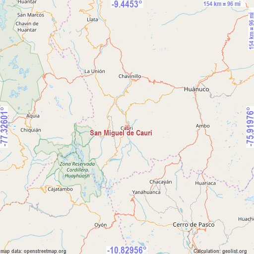
San Miguel de Cauri GPS coordinates[2]
10° 8' 17.448" South, 76° 37' 22.368" West
| Map corner | latitude | longitude |
|---|---|---|
| Upper-left | -9.4453°, | -77.32601° |
| Center: | -10.13818°, | -76.62288° |
| Lower-right: | -10.82956°, | -75.91976° |
| Map W x H: | 153.9×153.9 km | = 95.6×95.6mi |
| max Lat: | -0.96667° ⇑40.1% North |
| San Miguel de Cauri: | -10.13818° |
| min Lat: | ⇓59.9% South -18.01465° |
| min Long | San Miguel de C | max Long |
| -81.30472° | -76.62288° | -69.04167° |
| W 39.3%⇐ | ⇒60.7% E |
Elevation
Elevation of San Miguel de Cauri is 3586 m = 11765 ft, and this is 1267.3 m = 4158 ft above average elevation for this country.
| Max E: |
5022 m = 16476 ft | 17.2% |
| San Miguel de Cauri | 3586 m 11765 ft | |
| Avg. | 2318.7 m = 7607 ft | |
Min E: |
1 m = 3 ft | 82.8% |
See also: Peru elevation on elevation.city.
Geographical zone
San Miguel de Cauri is located in South Torrid zone (between Equator and Tropic of Capricorn). Distance of Equator is 1127.3 km =700.5 mi to North.| Distance of | km | miles | from San Miguel de Cauri |
|---|---|---|---|
| Equator | 1127.3 | 700.5 | to North |
| Tropic Capricorn | 1478.7 | 918.8 | to South |
| Antarctic Circle | 6273.9 | 3898.4 | to South |
| South Pole | 8879.8 | 5517.7 | to South |


Nearby cities:
15 places around San Miguel de Cauri: (largest is in red/bold)
• Baños
14.1 km =8.8 mi,  299°
299°
• Cahuac
31.8 km =19.8 mi,  358°
358°
• Cauri
0.4 km =0.2 mi,  207°
207°
• Cayna
29.6 km =18.4 mi,  120°
120°
• Chaupimarca
34.7 km =21.6 mi,  149°
149°
• Chavinillo
31.1 km =19.3 mi,  2°
2°
• Colpas
27.1 km =16.8 mi, 122°
• Huancapallac
35.5 km =22.1 mi,  40°
40°
• Jivia
14.1 km =8.8 mi,  334°
334°
• Margos
18.3 km =11.4 mi, 36°
• Obas
38.4 km =23.9 mi,  353°
353°
• Paucar
32.5 km =20.2 mi,  142°
142°
• Queropalca
20.4 km =12.7 mi,  256°
256°
• Rondos
18.6 km =11.6 mi,  337°
337°
• Yanacancha
11.7 km =7.3 mi,  192°
192°
Sources, notices
• [Note1] Compared only with cities in Peru existing in our database
• [Src1] Map data: © OpenStreetMap contributors (CC-BY-SA)
• [Src2] Other city data from geonames.org with taken over terms of usage.
• [Src3] Geographical zone / Annual Mean Temperature by Robert A. Rohde @ Wikipedia
