Tarma geodata
Tarma (Junin) is a seat of a third-order administrative division; located in Peru in America/Lima (GMT-5) time zone. With population of 51,350 people, there are 38 cities with bigger population in this country. Compared to other cities in Peru, 52.8% of cities are located further ↓South; 50.5% of cities are located further ←West and 56.1% of cities have lower elevation than Tarma. Note1


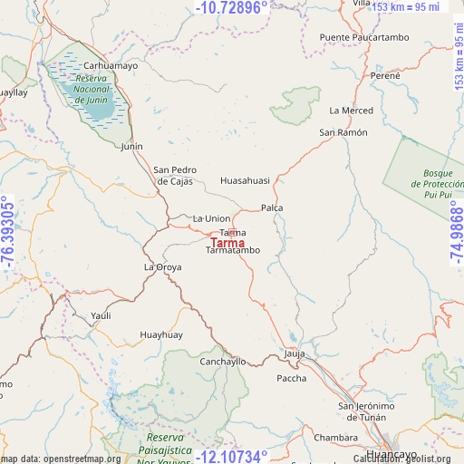
Tarma GPS coordinates[2]
11° 25' 8.364" South, 75° 41' 23.712" West
| Map corner | latitude | longitude |
|---|---|---|
| Upper-left | -10.72896°, | -76.39305° |
| Center: | -11.41899°, | -75.68992° |
| Lower-right: | -12.10734°, | -74.9868° |
| Map W x H: | 153.3×153.3 km | = 95.3×95.3mi |
| max Lat: | -0.96667° ⇑47.2% North |
| Tarma: | -11.41899° |
| min Lat: | ⇓52.8% South -18.01465° |
| min Long | Tarma | max Long |
| -81.30472° | -75.68992° | -69.04167° |
| W 50.5%⇐ | ⇒49.5% E |
Elevation
Elevation of Tarma is 3055 m = 10023 ft, and this is 736.3 m = 2416 ft above average elevation for this country.
| Max E: |
5022 m = 16476 ft | 43.9% |
| Tarma | 3055 m 10023 ft | |
| Avg. | 2318.7 m = 7607 ft | |
Min E: |
1 m = 3 ft | 56.1% |
See also: Tarma elevation on elevation.city.
Geographical zone
Tarma is located in South Torrid zone (between Equator and Tropic of Capricorn). Distance of Equator is 1269.7 km =789 mi to North.| Distance of | km | miles | from Tarma |
|---|---|---|---|
| Equator | 1269.7 | 789 | to North |
| Tropic Capricorn | 1336.2 | 830.3 | to South |
| Antarctic Circle | 6131.5 | 3809.9 | to South |
| South Pole | 8737.4 | 5429.2 | to South |


Nearby cities:
15 places around Tarma: (largest is in red/bold)
• Acobamba
8 km =5 mi,  22°
22°
• Acolla
38.1 km =23.7 mi,  155°
155°
• Chacapalpa
35.7 km =22.2 mi,  191°
191°
• Concho
36.4 km =22.6 mi, 159°
• Huasahuasi
17.7 km =11 mi, 15°
• La Oroya
25.4 km =15.8 mi,  244°
244°
• Leticia
8.2 km =5.1 mi,  302°
302°
• Marco
38.4 km =23.9 mi, 158°
• Paca
38 km =23.6 mi,  150°
150°
• Paccha
30.1 km =18.7 mi,  258°
258°
• Palca
15.5 km =9.6 mi,  58°
58°
• Palcamayo
16.6 km =10.3 mi,  326°
326°
• Pomacancha
36.2 km =22.5 mi,  168°
168°
• San Pedro de Cajas
26.4 km =16.4 mi,  315°
315°
• Tapo
14.1 km =8.8 mi,  77°
77°
Sources, notices
• [Note1] Compared only with cities in Peru existing in our database
• [Src1] Map data: © OpenStreetMap contributors (CC-BY-SA)
• [Src2] Other city data from geonames.org with taken over terms of usage.
• [Src3] Geographical zone / Annual Mean Temperature by Robert A. Rohde @ Wikipedia
