Tapo geodata
Tapo (Junin) is a seat of a third-order administrative division; located in Peru in America/Lima (GMT-5) time zone. In our database, there are 305 cities with bigger population. Compared to other cities in Peru, 53.2% of cities are located further ↓South; 51.7% of cities are located further ←West and 59.1% of cities have lower elevation than Tapo. Note1


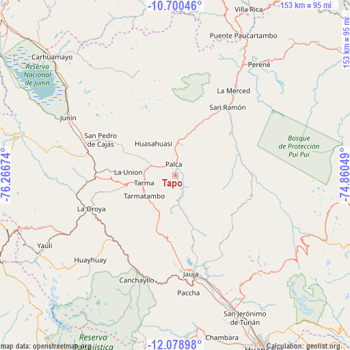
Tapo GPS coordinates[2]
11° 23' 26.016" South, 75° 33' 48.996" West
| Map corner | latitude | longitude |
|---|---|---|
| Upper-left | -10.70046°, | -76.26674° |
| Center: | -11.39056°, | -75.56361° |
| Lower-right: | -12.07898°, | -74.86049° |
| Map W x H: | 153.3×153.3 km | = 95.3×95.3mi |
| max Lat: | -0.96667° ⇑46.8% North |
| Tapo: | -11.39056° |
| min Lat: | ⇓53.2% South -18.01465° |
| min Long | Tapo | max Long |
| -81.30472° | -75.56361° | -69.04167° |
| W 51.7%⇐ | ⇒48.3% E |
Elevation
Elevation of Tapo is 3134 m = 10282 ft, and this is 815.3 m = 2675 ft above average elevation for this country.
| Max E: |
5022 m = 16476 ft | 40.9% |
| Tapo | 3134 m 10282 ft | |
| Avg. | 2318.7 m = 7607 ft | |
Min E: |
1 m = 3 ft | 59.1% |
See also: Peru elevation on elevation.city.
Geographical zone
Tapo is located in South Torrid zone (between Equator and Tropic of Capricorn). Distance of Equator is 1266.5 km =787 mi to North.| Distance of | km | miles | from Tapo |
|---|---|---|---|
| Equator | 1266.5 | 787 | to North |
| Tropic Capricorn | 1339.4 | 832.3 | to South |
| Antarctic Circle | 6134.7 | 3811.9 | to South |
| South Pole | 8740.6 | 5431.2 | to South |


Nearby cities:
15 places around Tapo: (largest is in red/bold)
• Acobamba
11.5 km =7.1 mi,  291°
291°
• Acolla
38 km =23.6 mi,  177°
177°
• Concho
37.2 km =23.1 mi, 181°
• Huasahuasi
16.6 km =10.3 mi,  326°
326°
• La Oroya
39.3 km =24.4 mi,  248°
248°
• Leticia
20.8 km =12.9 mi,  273°
273°
• Marco
39 km =24.2 mi, 179°
• Paca
36.5 km =22.7 mi,  171°
171°
• Palca
5 km =3.1 mi,  353°
353°
• Palcamayo
25.3 km =15.7 mi, 294°
• Pomacancha
39.2 km =24.4 mi,  189°
189°
• San Pedro de Cajas
36 km =22.4 mi,  295°
295°
• San Ramón
37.2 km =23.1 mi,  37°
37°
• Tarma
14.1 km =8.8 mi,  257°
257°
• Yauli
37.2 km =23.1 mi,  164°
164°
Sources, notices
• [Note1] Compared only with cities in Peru existing in our database
• [Src1] Map data: © OpenStreetMap contributors (CC-BY-SA)
• [Src2] Other city data from geonames.org with taken over terms of usage.
• [Src3] Geographical zone / Annual Mean Temperature by Robert A. Rohde @ Wikipedia
