Tambopata geodata
Tambopata (Madre de Dios) is a populated place; located in Peru in America/Lima (GMT-5) time zone. With population of 38,966 people, there are 47 cities with bigger population in this country. Compared to other cities in Peru, 58.6% of cities are located further ↑North; 99.1% of cities are located further ←West and 83.3% of cities have higher elevation than Tambopata. Note1
Administrative division(s):
- Level 1: Madre de Dios
- Level 2: Provincia de Tambopata
- Level 3: Tambopata


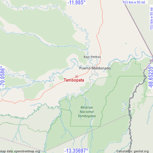
Tambopata GPS coordinates[2]
12° 40' 18.876" South, 69° 21' 19.692" West
| Map corner | latitude | longitude |
|---|---|---|
| Upper-left | -11.985°, | -70.0586° |
| Center: | -12.67191°, | -69.35547° |
| Lower-right: | -13.35697°, | -68.65235° |
| Map W x H: | 152.5×152.6 km | = 94.8×94.8mi |
| max Lat: | -0.96667° ⇑58.6% North |
| Tambopata: | -12.67191° |
| min Lat: | ⇓41.4% South -18.01465° |
| min Long | Tambopata | max Long |
| -81.30472° | -69.35547° | -69.04167° |
| W 99.1%⇐ | ⇒0.90000000000001% E |
Elevation
Elevation of Tambopata is 224 m = 735 ft, and this is 2094.7 m = 6872 ft below average elevation for this country.
| Max E: |
5022 m = 16476 ft | 83.3% |
| Avg. | 2318.7 m = 7607 ft | |
| Tambopata | 224 m = 735 ft | |
Min E: |
1 m = 3 ft | 16.7% |
See also: Peru elevation on elevation.city.
Geographical zone
Tambopata is located in South Torrid zone (between Equator and Tropic of Capricorn). Distance of this Southern Tropic circle is 1196.9 km =743.7 mi to South.| Distance of | km | miles | from Tambopata |
|---|---|---|---|
| Equator | 1409 | 875.5 | to North |
| Tropic Capricorn | 1196.9 | 743.7 | to South |
| Antarctic Circle | 5992.2 | 3723.4 | to South |
| South Pole | 8598.1 | 5342.6 | to South |


Nearby cities:
15 places around Tambopata: (largest is in red/bold)
• Ajoyani
183.2 km =113.8 mi,  209°
209°
• Coasa
161.8 km =100.5 mi,  204°
204°
• Corani
190 km =118.1 mi,  225°
225°
• Iberia
149.1 km =92.6 mi,  350°
350°
• Lanlacuni Bajo
146.1 km =90.8 mi, 231°
• Limbani
168 km =104.4 mi,  192°
192°
• Ollachea
176.4 km =109.6 mi,  223°
223°
• Patambuco
189.8 km =117.9 mi, 188°
• Phara
167.9 km =104.3 mi, 191°
• Puerto Maldonado
20.1 km =12.5 mi,  64°
64°
• Quince Mil
163.8 km =101.8 mi,  247°
247°
• San Lorenzo
134.1 km =83.3 mi,  2°
2°
• Sandia
173.8 km =108 mi,  182°
182°
• Usicayos
174.5 km =108.4 mi, 202°
• Yanahuaya
178.1 km =110.7 mi,  174°
174°
Sources, notices
• [Note1] Compared only with cities in Peru existing in our database
• [Src1] Map data: © OpenStreetMap contributors (CC-BY-SA)
• [Src2] Other city data from geonames.org with taken over terms of usage.
• [Src3] Geographical zone / Annual Mean Temperature by Robert A. Rohde @ Wikipedia
