Coasa geodata
Coasa (Puno) is a seat of a third-order administrative division; located in Peru in America/Lima (GMT-5) time zone. In our database, there are 305 cities with bigger population. Compared to other cities in Peru, 73.7% of cities are located further ↑North; 96.6% of cities are located further ←West and 98.8% of cities have lower elevation than Coasa. Note1


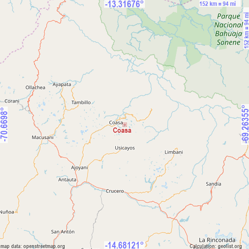
Coasa GPS coordinates[2]
14° 0' 0" South, 69° 58' 0.012" West
| Map corner | latitude | longitude |
|---|---|---|
| Upper-left | -13.31676°, | -70.6698° |
| Center: | -14°, | -69.96667° |
| Lower-right: | -14.68121°, | -69.26355° |
| Map W x H: | 151.7×151.7 km | = 94.3×94.3mi |
| max Lat: | -0.96667° ⇑73.7% North |
| Coasa: | -14° |
| min Lat: | ⇓26.3% South -18.01465° |
| min Long | Coasa | max Long |
| -81.30472° | -69.96667° | -69.04167° |
| W 96.6%⇐ | ⇒3.4% E |
Elevation
Elevation of Coasa is 4430 m = 14534 ft, and this is 2111.3 m = 6927 ft above average elevation for this country.
| Max E: |
5022 m = 16476 ft | 1.2% |
| Coasa | 4430 m 14534 ft | |
| Avg. | 2318.7 m = 7607 ft | |
Min E: |
1 m = 3 ft | 98.8% |
See also: Peru elevation on elevation.city.
Geographical zone
Coasa is located in South Torrid zone (between Equator and Tropic of Capricorn). Distance of this Southern Tropic circle is 1049.3 km =652 mi to South.| Distance of | km | miles | from Coasa |
|---|---|---|---|
| Equator | 1556.7 | 967.3 | to North |
| Tropic Capricorn | 1049.3 | 652 | to South |
| Antarctic Circle | 5844.5 | 3631.6 | to South |
| South Pole | 8450.4 | 5250.8 | to South |


Nearby cities:
15 places around Coasa: (largest is in red/bold)
• Ajoyani
27.5 km =17.1 mi,  246°
246°
• Antauta
61.9 km =38.5 mi,  224°
224°
• Corani
70.5 km =43.8 mi,  281°
281°
• Crucero
39.1 km =24.3 mi,  185°
185°
• Cuyocuyo
69.9 km =43.4 mi,  138°
138°
• Lanlacuni Bajo
75.2 km =46.7 mi,  319°
319°
• Limbani
34.2 km =21.3 mi,  118°
118°
• Macusani
51.2 km =31.8 mi,  259°
259°
• Ollachea
59.4 km =36.9 mi,  290°
290°
• Patambuco
54.8 km =34.1 mi, 136°
• Phara
36.8 km =22.9 mi, 117°
• Potoni
44.4 km =27.6 mi,  196°
196°
• Quiaca
82.1 km =51 mi,  125°
125°
• Sandia
63.1 km =39.2 mi,  114°
114°
• Usicayos
13.9 km =8.6 mi,  179°
179°
Sources, notices
• [Note1] Compared only with cities in Peru existing in our database
• [Src1] Map data: © OpenStreetMap contributors (CC-BY-SA)
• [Src2] Other city data from geonames.org with taken over terms of usage.
• [Src3] Geographical zone / Annual Mean Temperature by Robert A. Rohde @ Wikipedia
