Iberia geodata
Iberia (Madre de Dios) is a seat of a third-order administrative division; located in Peru in America/Lima (GMT-5) time zone. With population of 4,386 people, there are 253 cities with bigger population in this country. Compared to other cities in Peru, 53.4% of cities are located further ↓South; 98.1% of cities are located further ←West and 80.8% of cities have higher elevation than Iberia. Note1


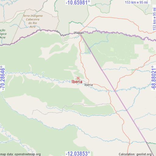
Iberia GPS coordinates[2]
11° 21' 0" South, 69° 34' 59.988" West
| Map corner | latitude | longitude |
|---|---|---|
| Upper-left | -10.65981°, | -70.28646° |
| Center: | -11.35°, | -69.58333° |
| Lower-right: | -12.03853°, | -68.88021° |
| Map W x H: | 153.3×153.3 km | = 95.3×95.3mi |
| max Lat: | -0.96667° ⇑46.6% North |
| Iberia: | -11.35° |
| min Lat: | ⇓53.4% South -18.01465° |
| min Long | Iberia | max Long |
| -81.30472° | -69.58333° | -69.04167° |
| W 98.1%⇐ | ⇒1.9% E |
Elevation
Elevation of Iberia is 306 m = 1004 ft, and this is 2012.7 m = 6603 ft below average elevation for this country.
| Max E: |
5022 m = 16476 ft | 80.8% |
| Avg. | 2318.7 m = 7607 ft | |
| Iberia | 306 m = 1004 ft | |
Min E: |
1 m = 3 ft | 19.2% |
See also: Peru elevation on elevation.city.
Geographical zone
Iberia is located in South Torrid zone (between Equator and Tropic of Capricorn). Distance of Equator is 1262 km =784.2 mi to North.| Distance of | km | miles | from Iberia |
|---|---|---|---|
| Equator | 1262 | 784.2 | to North |
| Tropic Capricorn | 1343.9 | 835.1 | to South |
| Antarctic Circle | 6139.2 | 3814.7 | to South |
| South Pole | 8745.1 | 5434 | to South |


Nearby cities:
15 places around Iberia: (largest is in red/bold)
• Challabamba
305.2 km =189.6 mi,  227°
227°
• Coasa
297.6 km =184.9 mi,  188°
188°
• Corani
301.5 km =187.3 mi,  201°
201°
• Iñapari
44.5 km =27.7 mi,  0°
0°
• Lanlacuni Bajo
253.9 km =157.8 mi, 200°
• Limbani
311.3 km =193.4 mi,  182°
182°
• Marcapata
291.1 km =180.9 mi,  211°
211°
• Ollachea
291.1 km =180.9 mi, 199°
• Paucartambo
308.9 km =191.9 mi,  224°
224°
• Pillcopata
257 km =159.7 mi, 222°
• Puerto Maldonado
144.7 km =89.9 mi,  162°
162°
• Quince Mil
244.8 km =152.1 mi, 211°
• Salvación
254.6 km =158.2 mi, 229°
• San Lorenzo
33.5 km =20.8 mi,  112°
112°
• Tambopata
149.1 km =92.6 mi,  170°
170°
Sources, notices
• [Note1] Compared only with cities in Peru existing in our database
• [Src1] Map data: © OpenStreetMap contributors (CC-BY-SA)
• [Src2] Other city data from geonames.org with taken over terms of usage.
• [Src3] Geographical zone / Annual Mean Temperature by Robert A. Rohde @ Wikipedia
