Corani geodata
Corani (Puno) is a seat of a third-order administrative division; located in Peru in America/Lima (GMT-5) time zone. In our database, there are 305 cities with bigger population. Compared to other cities in Peru, 72.4% of cities are located further ↑North; 92% of cities are located further ←West and 97.1% of cities have lower elevation than Corani. Note1


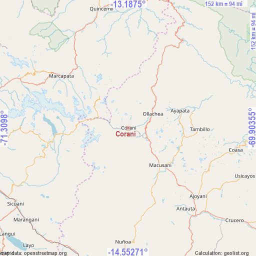
Corani GPS coordinates[2]
13° 52' 15.996" South, 70° 36' 24.012" West
| Map corner | latitude | longitude |
|---|---|---|
| Upper-left | -13.1875°, | -71.3098° |
| Center: | -13.87111°, | -70.60667° |
| Lower-right: | -14.55271°, | -69.90355° |
| Map W x H: | 151.8×151.8 km | = 94.3×94.3mi |
| max Lat: | -0.96667° ⇑72.4% North |
| Corani: | -13.87111° |
| min Lat: | ⇓27.6% South -18.01465° |
| min Long | Corani | max Long |
| -81.30472° | -70.60667° | -69.04167° |
| W 92%⇐ | ⇒8% E |
Elevation
Elevation of Corani is 4201 m = 13783 ft, and this is 1882.3 m = 6176 ft above average elevation for this country.
| Max E: |
5022 m = 16476 ft | 2.9% |
| Corani | 4201 m 13783 ft | |
| Avg. | 2318.7 m = 7607 ft | |
Min E: |
1 m = 3 ft | 97.1% |
See also: Peru elevation on elevation.city.
Geographical zone
Corani is located in South Torrid zone (between Equator and Tropic of Capricorn). Distance of this Southern Tropic circle is 1063.6 km =660.9 mi to South.| Distance of | km | miles | from Corani |
|---|---|---|---|
| Equator | 1542.3 | 958.3 | to North |
| Tropic Capricorn | 1063.6 | 660.9 | to South |
| Antarctic Circle | 5858.9 | 3640.6 | to South |
| South Pole | 8464.7 | 5259.7 | to South |


Nearby cities:
15 places around Corani: (largest is in red/bold)
• Ajoyani
50.7 km =31.5 mi,  120°
120°
• Antauta
64.2 km =39.9 mi,  156°
156°
• Callanca
67.1 km =41.7 mi,  239°
239°
• Coasa
70.5 km =43.8 mi,  101°
101°
• Huayna Alcalde
68.9 km =42.8 mi,  229°
229°
• Lanlacuni Bajo
47.8 km =29.7 mi,  25°
25°
• Macusani
30.1 km =18.7 mi,  141°
141°
• Marcapata
50.4 km =31.3 mi,  308°
308°
• Mosoc Cancha
69.4 km =43.1 mi, 228°
• Ollachea
14.6 km =9.1 mi,  65°
65°
• Potoni
80.2 km =49.8 mi, 135°
• Quince Mil
72.9 km =45.3 mi,  347°
347°
• Sicuani
80.2 km =49.8 mi, 236°
• Usicayos
74.6 km =46.4 mi,  112°
112°
• Ñuñoa
67.5 km =41.9 mi,  182°
182°
Sources, notices
• [Note1] Compared only with cities in Peru existing in our database
• [Src1] Map data: © OpenStreetMap contributors (CC-BY-SA)
• [Src2] Other city data from geonames.org with taken over terms of usage.
• [Src3] Geographical zone / Annual Mean Temperature by Robert A. Rohde @ Wikipedia
