San Vicente de Cañete geodata
San Vicente de Cañete (Lima region) is a populated place; located in Peru in America/Lima (GMT-5) time zone. With population of 25,517 people, there are 69 cities with bigger population in this country. Compared to other cities in Peru, 62.2% of cities are located further ↑North; 57.8% of cities are located further →East and 93.2% of cities have higher elevation than San Vicente de Cañete. Note1
Administrative division(s):
- Level 1: Lima region
- Level 2: Provincia de Cañete
- Level 3: San Vicente De Cañete


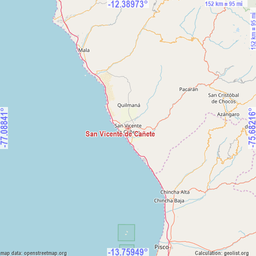
San Vicente de Cañete GPS coordinates[2]
13° 4' 32.016" South, 76° 23' 7.008" West
| Map corner | latitude | longitude |
|---|---|---|
| Upper-left | -12.38973°, | -77.08841° |
| Center: | -13.07556°, | -76.38528° |
| Lower-right: | -13.75949°, | -75.68216° |
| Map W x H: | 152.3×152.3 km | = 94.6×94.6mi |
| max Lat: | -0.96667° ⇑62.2% North |
| San Vicente de Cañete: | -13.07556° |
| min Lat: | ⇓37.8% South -18.01465° |
| min Long | San Vicente de | max Long |
| -81.30472° | -76.38528° | -69.04167° |
| W 42.2%⇐ | ⇒57.8% E |
Elevation
Elevation of San Vicente de Cañete is 45 m = 148 ft, and this is 2273.7 m = 7460 ft below average elevation for this country.
| Max E: |
5022 m = 16476 ft | 93.2% |
| Avg. | 2318.7 m = 7607 ft | |
| San Vicente de Cañete | 45 m = 148 ft | |
Min E: |
1 m = 3 ft | 6.8% |
See also: Peru elevation on elevation.city.
Geographical zone
San Vicente de Cañete is located in South Torrid zone (between Equator and Tropic of Capricorn). Distance of this Southern Tropic circle is 1152.1 km =715.9 mi to South.| Distance of | km | miles | from San Vicente de Cañete |
|---|---|---|---|
| Equator | 1453.9 | 903.4 | to North |
| Tropic Capricorn | 1152.1 | 715.9 | to South |
| Antarctic Circle | 5947.3 | 3695.5 | to South |
| South Pole | 8553.2 | 5314.7 | to South |


Nearby cities:
15 places around San Vicente de Cañete: (largest is in red/bold)
• Asia
38 km =23.6 mi,  328°
328°
• Catahuasi
61.7 km =38.3 mi,  60°
60°
• Chincha Alta
46.2 km =28.7 mi,  143°
143°
• Chincha Baja
48.9 km =30.4 mi,  150°
150°
• Chocos
59.4 km =36.9 mi,  72°
72°
• Coayllo
39.1 km =24.3 mi,  346°
346°
• El Carmen
58.8 km =36.5 mi, 142°
• Imperial
4 km =2.5 mi, 62°
• Mala
53.5 km =33.2 mi, 330°
• Nuevo Imperial
7.4 km =4.6 mi,  89°
89°
• Omas
63.1 km =39.2 mi,  10°
10°
• Quilmaná
14.1 km =8.8 mi,  1°
1°
• San Pedro
43.5 km =27 mi, 145°
• Sunampe
45.9 km =28.5 mi, 148°
• Tauripampa
62 km =38.5 mi,  28°
28°
Sources, notices
• [Note1] Compared only with cities in Peru existing in our database
• [Src1] Map data: © OpenStreetMap contributors (CC-BY-SA)
• [Src2] Other city data from geonames.org with taken over terms of usage.
• [Src3] Geographical zone / Annual Mean Temperature by Robert A. Rohde @ Wikipedia
