Mala geodata
Mala (Lima region) is a seat of a third-order administrative division; located in Peru in America/Lima (GMT-5) time zone. With population of 17,260 people, there are 92 cities with bigger population in this country. Compared to other cities in Peru, 58.5% of cities are located further ↑North; 61.1% of cities are located further →East and 94.2% of cities have higher elevation than Mala. Note1


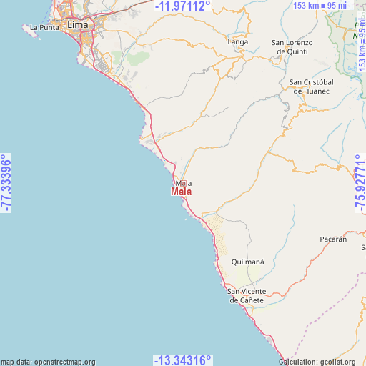
Mala GPS coordinates[2]
12° 39' 29.016" South, 76° 37' 50.988" West
| Map corner | latitude | longitude |
|---|---|---|
| Upper-left | -11.97112°, | -77.33396° |
| Center: | -12.65806°, | -76.63083° |
| Lower-right: | -13.34316°, | -75.92771° |
| Map W x H: | 152.6×152.6 km | = 94.8×94.8mi |
| max Lat: | -0.96667° ⇑58.5% North |
| Mala: | -12.65806° |
| min Lat: | ⇓41.5% South -18.01465° |
| min Long | Mala | max Long |
| -81.30472° | -76.63083° | -69.04167° |
| W 38.9%⇐ | ⇒61.1% E |
Elevation
Elevation of Mala is 34 m = 112 ft, and this is 2284.7 m = 7496 ft below average elevation for this country.
| Max E: |
5022 m = 16476 ft | 94.2% |
| Avg. | 2318.7 m = 7607 ft | |
| Mala | 34 m = 112 ft | |
Min E: |
1 m = 3 ft | 5.8% |
See also: Peru elevation on elevation.city.
Geographical zone
Mala is located in South Torrid zone (between Equator and Tropic of Capricorn). Distance of this Southern Tropic circle is 1198.5 km =744.7 mi to South.| Distance of | km | miles | from Mala |
|---|---|---|---|
| Equator | 1407.4 | 874.5 | to North |
| Tropic Capricorn | 1198.5 | 744.7 | to South |
| Antarctic Circle | 5993.7 | 3724.3 | to South |
| South Pole | 8599.6 | 5343.5 | to South |


Nearby cities:
15 places around Mala: (largest is in red/bold)
• Asia
15.6 km =9.7 mi,  153°
153°
• Calango
17.5 km =10.9 mi,  33°
33°
• Chilca
19.1 km =11.9 mi,  322°
322°
• Coayllo
19.7 km =12.2 mi,  115°
115°
• Imperial
53.8 km =33.4 mi, 145°
• Mariatana
55.7 km =34.6 mi,  35°
35°
• Nuevo Imperial
57.5 km =35.7 mi,  143°
143°
• Omas
40.9 km =25.4 mi,  67°
67°
• Pucusana
26.7 km =16.6 mi, 316°
• Punta Hermosa
41.4 km =25.7 mi,  330°
330°
• Quilmaná
42.2 km =26.2 mi, 140°
• Quinocay
54 km =33.6 mi,  53°
53°
• San Bartolo
34.7 km =21.6 mi, 331°
• San Vicente de Cañete
53.5 km =33.2 mi, 150°
• Tauripampa
56.4 km =35 mi,  81°
81°
Sources, notices
• [Note1] Compared only with cities in Peru existing in our database
• [Src1] Map data: © OpenStreetMap contributors (CC-BY-SA)
• [Src2] Other city data from geonames.org with taken over terms of usage.
• [Src3] Geographical zone / Annual Mean Temperature by Robert A. Rohde @ Wikipedia
