Nuevo Imperial geodata
Nuevo Imperial (Lima region) is a seat of a third-order administrative division; located in Peru in America/Lima (GMT-5) time zone. With population of 32,344 people, there are 55 cities with bigger population in this country. Compared to other cities in Peru, 62.2% of cities are located further ↑North; 56.8% of cities are located further →East and 86.5% of cities have higher elevation than Nuevo Imperial. Note1
Administrative division(s):
- Level 1: Lima region
- Level 2: Provincia de Cañete
- Level 3: Nuevo Imperial


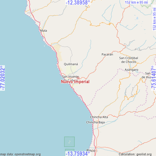
Nuevo Imperial GPS coordinates[2]
13° 4' 31.476" South, 76° 19' 1.884" West
| Map corner | latitude | longitude |
|---|---|---|
| Upper-left | -12.38958°, | -77.02032° |
| Center: | -13.07541°, | -76.31719° |
| Lower-right: | -13.75934°, | -75.61407° |
| Map W x H: | 152.3×152.3 km | = 94.6×94.6mi |
| max Lat: | -0.96667° ⇑62.2% North |
| Nuevo Imperial: | -13.07541° |
| min Lat: | ⇓37.8% South -18.01465° |
| min Long | Nuevo Imperial | max Long |
| -81.30472° | -76.31719° | -69.04167° |
| W 43.2%⇐ | ⇒56.8% E |
Elevation
Elevation of Nuevo Imperial is 153 m = 502 ft, and this is 2165.7 m = 7105 ft below average elevation for this country.
| Max E: |
5022 m = 16476 ft | 86.5% |
| Avg. | 2318.7 m = 7607 ft | |
| Nuevo Imperial | 153 m = 502 ft | |
Min E: |
1 m = 3 ft | 13.5% |
See also: Peru elevation on elevation.city.
Geographical zone
Nuevo Imperial is located in South Torrid zone (between Equator and Tropic of Capricorn). Distance of this Southern Tropic circle is 1152.1 km =715.9 mi to South.| Distance of | km | miles | from Nuevo Imperial |
|---|---|---|---|
| Equator | 1453.8 | 903.3 | to North |
| Tropic Capricorn | 1152.1 | 715.9 | to South |
| Antarctic Circle | 5947.3 | 3695.5 | to South |
| South Pole | 8553.2 | 5314.7 | to South |


Nearby cities:
15 places around Nuevo Imperial: (largest is in red/bold)
• Asia
42.3 km =26.3 mi,  320°
320°
• Catahuasi
55.4 km =34.4 mi,  56°
56°
• Chincha Alta
42.2 km =26.2 mi,  151°
151°
• Chincha Baja
45.8 km =28.5 mi,  158°
158°
• Chocos
52.4 km =32.6 mi,  69°
69°
• Coayllo
41.3 km =25.7 mi,  336°
336°
• El Carmen
54.7 km =34 mi, 149°
• Huangascar
56.2 km =34.9 mi, 69°
• Imperial
4.2 km =2.6 mi,  295°
295°
• Mala
57.5 km =35.7 mi, 323°
• Quilmaná
15.7 km =9.8 mi,  333°
333°
• San Pedro
39.8 km =24.7 mi, 154°
• San Vicente de Cañete
7.4 km =4.6 mi,  269°
269°
• Sunampe
42.5 km =26.4 mi, 156°
• Tauripampa
58.9 km =36.6 mi,  21°
21°
Sources, notices
• [Note1] Compared only with cities in Peru existing in our database
• [Src1] Map data: © OpenStreetMap contributors (CC-BY-SA)
• [Src2] Other city data from geonames.org with taken over terms of usage.
• [Src3] Geographical zone / Annual Mean Temperature by Robert A. Rohde @ Wikipedia
