Chincha Alta geodata
Chincha Alta (Ica) is a seat of a third-order administrative division; located in Peru in America/Lima (GMT-5) time zone. With population of 153,076 people, there are 16 cities with bigger population in this country. Compared to other cities in Peru, 65.3% of cities are located further ↑North; 53.9% of cities are located further →East and 88.9% of cities have higher elevation than Chincha Alta. Note1


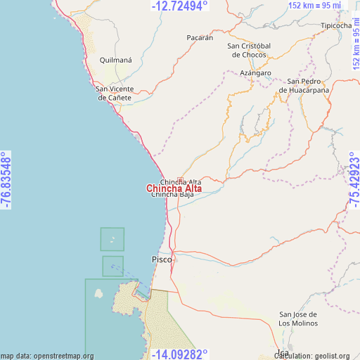
Chincha Alta GPS coordinates[2]
13° 24' 35.46" South, 76° 7' 56.46" West
| Map corner | latitude | longitude |
|---|---|---|
| Upper-left | -12.72494°, | -76.83548° |
| Center: | -13.40985°, | -76.13235° |
| Lower-right: | -14.09282°, | -75.42923° |
| Map W x H: | 152.1×152.1 km | = 94.5×94.5mi |
| max Lat: | -0.96667° ⇑65.3% North |
| Chincha Alta: | -13.40985° |
| min Lat: | ⇓34.7% South -18.01465° |
| min Long | Chincha Alta | max Long |
| -81.30472° | -76.13235° | -69.04167° |
| W 46.1%⇐ | ⇒53.9% E |
Elevation
Elevation of Chincha Alta is 111 m = 364 ft, and this is 2207.7 m = 7243 ft below average elevation for this country.
| Max E: |
5022 m = 16476 ft | 88.9% |
| Avg. | 2318.7 m = 7607 ft | |
| Chincha Alta | 111 m = 364 ft | |
Min E: |
1 m = 3 ft | 11.1% |
See also: Chincha Alta elevation on elevation.city.
Geographical zone
Chincha Alta is located in South Torrid zone (between Equator and Tropic of Capricorn). Distance of this Southern Tropic circle is 1114.9 km =692.8 mi to South.| Distance of | km | miles | from Chincha Alta |
|---|---|---|---|
| Equator | 1491 | 926.5 | to North |
| Tropic Capricorn | 1114.9 | 692.8 | to South |
| Antarctic Circle | 5910.1 | 3672.4 | to South |
| South Pole | 8516 | 5291.6 | to South |


Nearby cities:
15 places around Chincha Alta: (largest is in red/bold)
• Chincha Baja
6.4 km =4 mi,  211°
211°
• El Carmen
12.7 km =7.9 mi,  140°
140°
• Humay
42.4 km =26.3 mi, 143°
• Imperial
45.7 km =28.4 mi,  328°
328°
• Independencia
34 km =21.1 mi,  161°
161°
• Nuevo Imperial
42.2 km =26.2 mi, 331°
• Paracas
52.8 km =32.8 mi,  195°
195°
• Pisco
34.3 km =21.3 mi,  193°
193°
• Quilmaná
57.9 km =36 mi, 332°
• San Clemente
28.6 km =17.8 mi,  183°
183°
• San Juan
57.2 km =35.5 mi,  65°
65°
• San Pedro
3.1 km =1.9 mi,  292°
292°
• San Vicente de Cañete
46.2 km =28.7 mi,  323°
323°
• Sunampe
3.9 km =2.4 mi,  240°
240°
• Villa Tupac Amaru
33.6 km =20.9 mi, 183°
Sources, notices
• [Note1] Compared only with cities in Peru existing in our database
• [Src1] Map data: © OpenStreetMap contributors (CC-BY-SA)
• [Src2] Other city data from geonames.org with taken over terms of usage.
• [Src3] Geographical zone / Annual Mean Temperature by Robert A. Rohde @ Wikipedia
