Quilmaná geodata
Quilmaná (Lima region) is a populated place; located in Peru in America/Lima (GMT-5) time zone. With population of 6,442 people, there are 198 cities with bigger population in this country. Compared to other cities in Peru, 60.9% of cities are located further ↑North; 57.7% of cities are located further →East and 86% of cities have higher elevation than Quilmaná. Note1


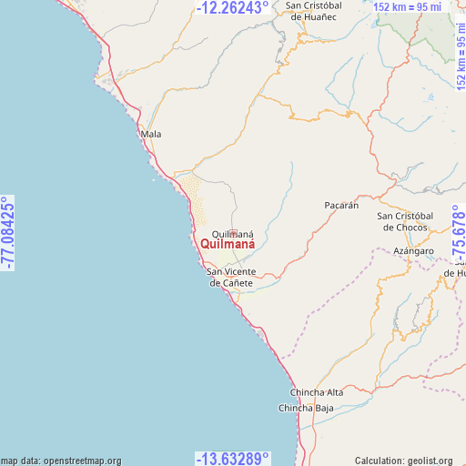
Quilmaná GPS coordinates[2]
12° 56' 54.96" South, 76° 22' 52.032" West
| Map corner | latitude | longitude |
|---|---|---|
| Upper-left | -12.26243°, | -77.08425° |
| Center: | -12.9486°, | -76.38112° |
| Lower-right: | -13.63289°, | -75.678° |
| Map W x H: | 152.4×152.4 km | = 94.7×94.7mi |
| max Lat: | -0.96667° ⇑60.9% North |
| Quilmaná: | -12.9486° |
| min Lat: | ⇓39.1% South -18.01465° |
| min Long | Quilmaná | max Long |
| -81.30472° | -76.38112° | -69.04167° |
| W 42.3%⇐ | ⇒57.7% E |
Elevation
Elevation of Quilmaná is 162 m = 531 ft, and this is 2156.7 m = 7076 ft below average elevation for this country.
| Max E: |
5022 m = 16476 ft | 86% |
| Avg. | 2318.7 m = 7607 ft | |
| Quilmaná | 162 m = 531 ft | |
Min E: |
1 m = 3 ft | 14% |
See also: Peru elevation on elevation.city.
Geographical zone
Quilmaná is located in South Torrid zone (between Equator and Tropic of Capricorn). Distance of this Southern Tropic circle is 1166.2 km =724.6 mi to South.| Distance of | km | miles | from Quilmaná |
|---|---|---|---|
| Equator | 1439.7 | 894.6 | to North |
| Tropic Capricorn | 1166.2 | 724.6 | to South |
| Antarctic Circle | 5961.4 | 3704.2 | to South |
| South Pole | 8567.3 | 5323.5 | to South |


Nearby cities:
15 places around Quilmaná: (largest is in red/bold)
• Asia
27.2 km =16.9 mi,  312°
312°
• Calango
50.1 km =31.1 mi,  339°
339°
• Catahuasi
55.6 km =34.5 mi,  72°
72°
• Chincha Alta
57.9 km =36 mi,  152°
152°
• Chocos
56.3 km =35 mi,  86°
86°
• Coayllo
25.7 km =16 mi, 338°
• Huangascar
59.9 km =37.2 mi,  84°
84°
• Imperial
12.7 km =7.9 mi,  165°
165°
• Mala
42.2 km =26.2 mi,  320°
320°
• Nuevo Imperial
15.7 km =9.8 mi, 153°
• Omas
49.2 km =30.6 mi,  12°
12°
• San Pedro
55.5 km =34.5 mi, 154°
• San Vicente de Cañete
14.1 km =8.8 mi,  181°
181°
• Sunampe
58.2 km =36.2 mi,  156°
156°
• Tauripampa
49.7 km =30.9 mi,  35°
35°
Sources, notices
• [Note1] Compared only with cities in Peru existing in our database
• [Src1] Map data: © OpenStreetMap contributors (CC-BY-SA)
• [Src2] Other city data from geonames.org with taken over terms of usage.
• [Src3] Geographical zone / Annual Mean Temperature by Robert A. Rohde @ Wikipedia
