Imperial geodata
Imperial (Lima region) is a seat of a third-order administrative division; located in Peru in America/Lima (GMT-5) time zone. With population of 32,344 people, there are 55 cities with bigger population in this country. Compared to other cities in Peru, 61.9% of cities are located further ↑North; 57.5% of cities are located further →East and 90.2% of cities have higher elevation than Imperial. Note1


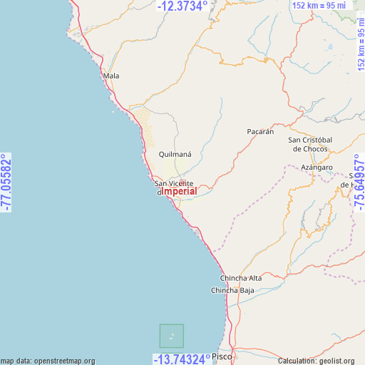
Imperial GPS coordinates[2]
13° 3' 33.372" South, 76° 21' 9.684" West
| Map corner | latitude | longitude |
|---|---|---|
| Upper-left | -12.3734°, | -77.05582° |
| Center: | -13.05927°, | -76.35269° |
| Lower-right: | -13.74324°, | -75.64957° |
| Map W x H: | 152.3×152.3 km | = 94.6×94.6mi |
| max Lat: | -0.96667° ⇑61.9% North |
| Imperial: | -13.05927° |
| min Lat: | ⇓38.1% South -18.01465° |
| min Long | Imperial | max Long |
| -81.30472° | -76.35269° | -69.04167° |
| W 42.5%⇐ | ⇒57.5% E |
Elevation
Elevation of Imperial is 91 m = 299 ft, and this is 2227.7 m = 7309 ft below average elevation for this country.
| Max E: |
5022 m = 16476 ft | 90.2% |
| Avg. | 2318.7 m = 7607 ft | |
| Imperial | 91 m = 299 ft | |
Min E: |
1 m = 3 ft | 9.8% |
See also: Peru elevation on elevation.city.
Geographical zone
Imperial is located in South Torrid zone (between Equator and Tropic of Capricorn). Distance of this Southern Tropic circle is 1153.9 km =717 mi to South.| Distance of | km | miles | from Imperial |
|---|---|---|---|
| Equator | 1452.1 | 902.3 | to North |
| Tropic Capricorn | 1153.9 | 717 | to South |
| Antarctic Circle | 5949.1 | 3696.6 | to South |
| South Pole | 8555 | 5315.8 | to South |


Nearby cities:
15 places around Imperial: (largest is in red/bold)
• Asia
38.5 km =23.9 mi,  322°
322°
• Catahuasi
57.7 km =35.9 mi,  59°
59°
• Chincha Alta
45.7 km =28.4 mi,  148°
148°
• Chincha Baja
48.9 km =30.4 mi,  155°
155°
• Chocos
55.4 km =34.4 mi,  73°
73°
• Coayllo
38.3 km =23.8 mi,  341°
341°
• El Carmen
58.2 km =36.2 mi, 146°
• Huangascar
59.3 km =36.8 mi, 72°
• Mala
53.8 km =33.4 mi,  325°
325°
• Nuevo Imperial
4.2 km =2.6 mi,  115°
115°
• Quilmaná
12.7 km =7.9 mi,  345°
345°
• San Pedro
43.2 km =26.8 mi, 150°
• San Vicente de Cañete
4 km =2.5 mi,  242°
242°
• Sunampe
45.7 km =28.4 mi, 153°
• Tauripampa
58.8 km =36.5 mi,  25°
25°
Sources, notices
• [Note1] Compared only with cities in Peru existing in our database
• [Src1] Map data: © OpenStreetMap contributors (CC-BY-SA)
• [Src2] Other city data from geonames.org with taken over terms of usage.
• [Src3] Geographical zone / Annual Mean Temperature by Robert A. Rohde @ Wikipedia
