Pillcopata geodata
Pillcopata (Cusco) is a seat of a third-order administrative division; located in Peru in America/Lima (GMT-5) time zone. In our database, there are 305 cities with bigger population. Compared to other cities in Peru, 62% of cities are located further ↑North; 89.2% of cities are located further ←West and 72.9% of cities have higher elevation than Pillcopata. Note1


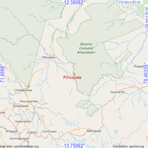
Pillcopata GPS coordinates[2]
13° 4' 0.012" South, 71° 10' 0.012" West
| Map corner | latitude | longitude |
|---|---|---|
| Upper-left | -12.38082°, | -71.8698° |
| Center: | -13.06667°, | -71.16667° |
| Lower-right: | -13.75062°, | -70.46355° |
| Map W x H: | 152.3×152.3 km | = 94.6×94.6mi |
| max Lat: | -0.96667° ⇑62% North |
| Pillcopata: | -13.06667° |
| min Lat: | ⇓38% South -18.01465° |
| min Long | Pillcopata | max Long |
| -81.30472° | -71.16667° | -69.04167° |
| W 89.2%⇐ | ⇒10.8% E |
Elevation
Elevation of Pillcopata is 968 m = 3176 ft, and this is 1350.7 m = 4431 ft below average elevation for this country.
| Max E: |
5022 m = 16476 ft | 72.9% |
| Avg. | 2318.7 m = 7607 ft | |
| Pillcopata | 968 m = 3176 ft | |
Min E: |
1 m = 3 ft | 27.1% |
See also: Peru elevation on elevation.city.
Geographical zone
Pillcopata is located in South Torrid zone (between Equator and Tropic of Capricorn). Distance of this Southern Tropic circle is 1153 km =716.4 mi to South.| Distance of | km | miles | from Pillcopata |
|---|---|---|---|
| Equator | 1452.9 | 902.8 | to North |
| Tropic Capricorn | 1153 | 716.4 | to South |
| Antarctic Circle | 5948.3 | 3696.1 | to South |
| South Pole | 8554.2 | 5315.3 | to South |


Nearby cities:
15 places around Pillcopata: (largest is in red/bold)
• Caicay
82.3 km =51.1 mi,  224°
224°
• Ccatca
73.4 km =45.6 mi, 215°
• Challabamba
55 km =34.2 mi,  253°
253°
• Colquepata
63.2 km =39.3 mi,  239°
239°
• Coya
87 km =54.1 mi, 245°
• Huaro
85.8 km =53.3 mi, 216°
• Marcapata
61.8 km =38.4 mi,  160°
160°
• Ocongate
66.6 km =41.4 mi,  200°
200°
• Paucartambo
53.9 km =33.5 mi, 239°
• Pisac
83.6 km =51.9 mi, 241°
• Quince Mil
48.3 km =30 mi,  112°
112°
• Salvación
33.5 km =20.8 mi,  320°
320°
• San Salvador
81.1 km =50.4 mi,  234°
234°
• Taray
85.8 km =53.3 mi, 242°
• Urcos
84.7 km =52.6 mi, 215°
Sources, notices
• [Note1] Compared only with cities in Peru existing in our database
• [Src1] Map data: © OpenStreetMap contributors (CC-BY-SA)
• [Src2] Other city data from geonames.org with taken over terms of usage.
• [Src3] Geographical zone / Annual Mean Temperature by Robert A. Rohde @ Wikipedia
