Marcapata geodata
Marcapata (Cusco) is a seat of a third-order administrative division; located in Peru in America/Lima (GMT-5) time zone. In our database, there are 305 cities with bigger population. Compared to other cities in Peru, 67.9% of cities are located further ↑North; 90.1% of cities are located further ←West and 55.8% of cities have lower elevation than Marcapata. Note1


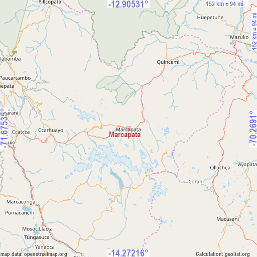
Marcapata GPS coordinates[2]
13° 35' 22.992" South, 70° 58' 19.992" West
| Map corner | latitude | longitude |
|---|---|---|
| Upper-left | -12.90531°, | -71.67535° |
| Center: | -13.58972°, | -70.97222° |
| Lower-right: | -14.27216°, | -70.2691° |
| Map W x H: | 152×152 km | = 94.4×94.4mi |
| max Lat: | -0.96667° ⇑67.9% North |
| Marcapata: | -13.58972° |
| min Lat: | ⇓32.1% South -18.01465° |
| min Long | Marcapata | max Long |
| -81.30472° | -70.97222° | -69.04167° |
| W 90.1%⇐ | ⇒9.9% E |
Elevation
Elevation of Marcapata is 3038 m = 9967 ft, and this is 719.3 m = 2360 ft above average elevation for this country.
| Max E: |
5022 m = 16476 ft | 44.2% |
| Marcapata | 3038 m 9967 ft | |
| Avg. | 2318.7 m = 7607 ft | |
Min E: |
1 m = 3 ft | 55.8% |
See also: Peru elevation on elevation.city.
Geographical zone
Marcapata is located in South Torrid zone (between Equator and Tropic of Capricorn). Distance of this Southern Tropic circle is 1094.9 km =680.3 mi to South.| Distance of | km | miles | from Marcapata |
|---|---|---|---|
| Equator | 1511 | 938.9 | to North |
| Tropic Capricorn | 1094.9 | 680.3 | to South |
| Antarctic Circle | 5890.1 | 3659.9 | to South |
| South Pole | 8496 | 5279.2 | to South |


Nearby cities:
15 places around Marcapata: (largest is in red/bold)
• Callanca
68.3 km =42.4 mi,  195°
195°
• Ccatca
63.5 km =39.5 mi,  268°
268°
• Corani
50.4 km =31.3 mi,  128°
128°
• Cullcuyre
68 km =42.3 mi,  214°
214°
• Cusipata
66.9 km =41.6 mi,  238°
238°
• Jayobamba
68.7 km =42.7 mi,  215°
215°
• Lanlacuni Bajo
61.2 km =38 mi,  78°
78°
• Lima Pampa
68.1 km =42.3 mi, 215°
• Ocongate
44.8 km =27.8 mi,  264°
264°
• Ollachea
58.5 km =36.4 mi,  115°
115°
• Pillcopata
61.8 km =38.4 mi,  340°
340°
• Pitumarca
63.6 km =39.5 mi,  228°
228°
• Qquea
68.3 km =42.4 mi, 220°
• Quince Mil
46.4 km =28.8 mi,  30°
30°
• Quiquijana
66.5 km =41.3 mi,  247°
247°
Sources, notices
• [Note1] Compared only with cities in Peru existing in our database
• [Src1] Map data: © OpenStreetMap contributors (CC-BY-SA)
• [Src2] Other city data from geonames.org with taken over terms of usage.
• [Src3] Geographical zone / Annual Mean Temperature by Robert A. Rohde @ Wikipedia
