Ocongate geodata
Ocongate (Cusco) is a seat of a third-order administrative division; located in Peru in America/Lima (GMT-5) time zone. In our database, there are 305 cities with bigger population. Compared to other cities in Peru, 68.7% of cities are located further ↑North; 87.4% of cities are located further ←West and 82.8% of cities have lower elevation than Ocongate. Note1


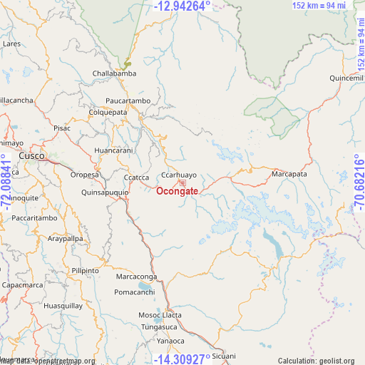
Ocongate GPS coordinates[2]
13° 37' 36.984" South, 71° 23' 7.008" West
| Map corner | latitude | longitude |
|---|---|---|
| Upper-left | -12.94264°, | -72.08841° |
| Center: | -13.62694°, | -71.38528° |
| Lower-right: | -14.30927°, | -70.68216° |
| Map W x H: | 152×152 km | = 94.4×94.4mi |
| max Lat: | -0.96667° ⇑68.7% North |
| Ocongate: | -13.62694° |
| min Lat: | ⇓31.3% South -18.01465° |
| min Long | Ocongate | max Long |
| -81.30472° | -71.38528° | -69.04167° |
| W 87.4%⇐ | ⇒12.6% E |
Elevation
Elevation of Ocongate is 3586 m = 11765 ft, and this is 1267.3 m = 4158 ft above average elevation for this country.
| Max E: |
5022 m = 16476 ft | 17.2% |
| Ocongate | 3586 m 11765 ft | |
| Avg. | 2318.7 m = 7607 ft | |
Min E: |
1 m = 3 ft | 82.8% |
See also: Peru elevation on elevation.city.
Geographical zone
Ocongate is located in South Torrid zone (between Equator and Tropic of Capricorn). Distance of this Southern Tropic circle is 1090.7 km =677.7 mi to South.| Distance of | km | miles | from Ocongate |
|---|---|---|---|
| Equator | 1515.2 | 941.5 | to North |
| Tropic Capricorn | 1090.7 | 677.7 | to South |
| Antarctic Circle | 5886 | 3657.4 | to South |
| South Pole | 8491.9 | 5276.6 | to South |


Nearby cities:
15 places around Ocongate: (largest is in red/bold)
• Andahuaylillas
32.2 km =20 mi,  260°
260°
• Caicay
34.1 km =21.2 mi,  275°
275°
• Ccatca
19 km =11.8 mi, 277°
• Checacupe
45.1 km =28 mi,  189°
189°
• Colquepata
43.1 km =26.8 mi,  314°
314°
• Cusipata
33.5 km =20.8 mi,  201°
201°
• Huaro
27.9 km =17.3 mi, 255°
• Lucre
38.1 km =23.7 mi,  268°
268°
• Marcapata
44.8 km =27.8 mi,  84°
84°
• Oropesa
42 km =26.1 mi, 275°
• Paucartambo
41.3 km =25.7 mi,  326°
326°
• Pitumarca
38.5 km =23.9 mi,  183°
183°
• Quiquijana
27.4 km =17 mi,  217°
217°
• San Salvador
44.5 km =27.7 mi,  289°
289°
• Urcos
26.5 km =16.5 mi, 255°
Sources, notices
• [Note1] Compared only with cities in Peru existing in our database
• [Src1] Map data: © OpenStreetMap contributors (CC-BY-SA)
• [Src2] Other city data from geonames.org with taken over terms of usage.
• [Src3] Geographical zone / Annual Mean Temperature by Robert A. Rohde @ Wikipedia
