Potoni geodata
Potoni (Puno) is a seat of a third-order administrative division; located in Peru in America/Lima (GMT-5) time zone. In our database, there are 305 cities with bigger population. Compared to other cities in Peru, 81.4% of cities are located further ↑North; 95.7% of cities are located further ←West and 96.7% of cities have lower elevation than Potoni. Note1


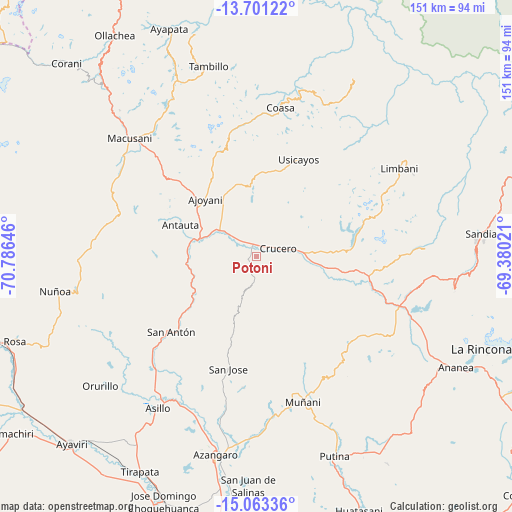
Potoni GPS coordinates[2]
14° 22' 59.988" South, 70° 4' 59.988" West
| Map corner | latitude | longitude |
|---|---|---|
| Upper-left | -13.70122°, | -70.78646° |
| Center: | -14.38333°, | -70.08333° |
| Lower-right: | -15.06336°, | -69.38021° |
| Map W x H: | 151.5×151.5 km | = 94.1×94.1mi |
| max Lat: | -0.96667° ⇑81.4% North |
| Potoni: | -14.38333° |
| min Lat: | ⇓18.6% South -18.01465° |
| min Long | Potoni | max Long |
| -81.30472° | -70.08333° | -69.04167° |
| W 95.7%⇐ | ⇒4.3% E |
Elevation
Elevation of Potoni is 4174 m = 13694 ft, and this is 1855.3 m = 6087 ft above average elevation for this country.
| Max E: |
5022 m = 16476 ft | 3.3% |
| Potoni | 4174 m 13694 ft | |
| Avg. | 2318.7 m = 7607 ft | |
Min E: |
1 m = 3 ft | 96.7% |
See also: Peru elevation on elevation.city.
Geographical zone
Potoni is located in South Torrid zone (between Equator and Tropic of Capricorn). Distance of this Southern Tropic circle is 1006.6 km =625.5 mi to South.| Distance of | km | miles | from Potoni |
|---|---|---|---|
| Equator | 1599.3 | 993.8 | to North |
| Tropic Capricorn | 1006.6 | 625.5 | to South |
| Antarctic Circle | 5801.9 | 3605.1 | to South |
| South Pole | 8407.8 | 5224.4 | to South |


Nearby cities:
15 places around Potoni: (largest is in red/bold)
• Ajoyani
33.9 km =21.1 mi,  338°
338°
• Antauta
30.6 km =19 mi,  266°
266°
• Asillo
52.9 km =32.9 mi,  212°
212°
• Azángaro
59.6 km =37 mi,  191°
191°
• Coasa
44.4 km =27.6 mi,  16°
16°
• Crucero
9.7 km =6 mi,  67°
67°
• Cuyocuyo
59.6 km =37 mi,  99°
99°
• Limbani
49.9 km =31 mi,  58°
58°
• Macusani
50.4 km =31.3 mi,  311°
311°
• Muñani
45 km =28 mi,  161°
161°
• Orurillo
60.2 km =37.4 mi,  230°
230°
• Patambuco
50.1 km =31.1 mi,  86°
86°
• Phara
52.1 km =32.4 mi, 60°
• Usicayos
31.4 km =19.5 mi, 23°
• Ñuñoa
60.4 km =37.5 mi,  259°
259°
Sources, notices
• [Note1] Compared only with cities in Peru existing in our database
• [Src1] Map data: © OpenStreetMap contributors (CC-BY-SA)
• [Src2] Other city data from geonames.org with taken over terms of usage.
• [Src3] Geographical zone / Annual Mean Temperature by Robert A. Rohde @ Wikipedia
