Huacar geodata
Huacar (Huanuco) is a seat of a third-order administrative division; located in Peru in America/Lima (GMT-5) time zone. In our database, there are 305 cities with bigger population. Compared to other cities in Peru, 59.7% of cities are located further ↓South; 55.7% of cities are located further →East and 64.2% of cities have higher elevation than Huacar. Note1


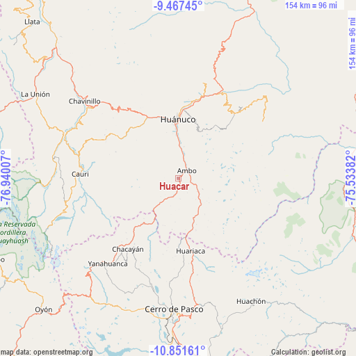
Huacar GPS coordinates[2]
10° 9' 37.008" South, 76° 14' 12.984" West
| Map corner | latitude | longitude |
|---|---|---|
| Upper-left | -9.46745°, | -76.94007° |
| Center: | -10.16028°, | -76.23694° |
| Lower-right: | -10.85161°, | -75.53382° |
| Map W x H: | 153.9×153.9 km | = 95.6×95.6mi |
| max Lat: | -0.96667° ⇑40.3% North |
| Huacar: | -10.16028° |
| min Lat: | ⇓59.7% South -18.01465° |
| min Long | Huacar | max Long |
| -81.30472° | -76.23694° | -69.04167° |
| W 44.3%⇐ | ⇒55.7% E |
Elevation
Elevation of Huacar is 2117 m = 6946 ft, and this is 201.7 m = 662 ft below average elevation for this country.
| Max E: |
5022 m = 16476 ft | 64.2% |
| Avg. | 2318.7 m = 7607 ft | |
| Huacar | 2117 m = 6946 ft | |
Min E: |
1 m = 3 ft | 35.8% |
See also: Peru elevation on elevation.city.
Geographical zone
Huacar is located in South Torrid zone (between Equator and Tropic of Capricorn). Distance of Equator is 1129.7 km =702 mi to North.| Distance of | km | miles | from Huacar |
|---|---|---|---|
| Equator | 1129.7 | 702 | to North |
| Tropic Capricorn | 1476.2 | 917.3 | to South |
| Antarctic Circle | 6271.5 | 3896.9 | to South |
| South Pole | 8877.3 | 5516.1 | to South |


Nearby cities:
15 places around Huacar: (largest is in red/bold)
• Ambo
4.8 km =3 mi,  47°
47°
• Cayhuayna
22.5 km =14 mi,  356°
356°
• Cayna
20.7 km =12.9 mi,  233°
233°
• Colpas
22.8 km =14.2 mi,  238°
238°
• Conchamarca
13.8 km =8.6 mi,  9°
9°
• Huancapallac
35.4 km =22 mi,  326°
326°
• Huariaca
31.7 km =19.7 mi,  170°
170°
• Huánuco
25.5 km =15.8 mi, 358°
• Margos
35.7 km =22.2 mi,  298°
298°
• Mosca
21.2 km =13.2 mi,  196°
196°
• Pallanchacra
28.4 km =17.6 mi,  179°
179°
• Paucar
32.6 km =20.3 mi,  223°
223°
• Paucarbamba
24 km =14.9 mi,  3°
3°
• San Rafael
20.6 km =12.8 mi,  163°
163°
• Tomay Kichwa
9.6 km =6 mi,  16°
16°
Sources, notices
• [Note1] Compared only with cities in Peru existing in our database
• [Src1] Map data: © OpenStreetMap contributors (CC-BY-SA)
• [Src2] Other city data from geonames.org with taken over terms of usage.
• [Src3] Geographical zone / Annual Mean Temperature by Robert A. Rohde @ Wikipedia
