Tomay Kichwa geodata
Tomay Kichwa (Huanuco) is a seat of a third-order administrative division; located in Peru in America/Lima (GMT-5) time zone. In our database, there are 305 cities with bigger population. Compared to other cities in Peru, 60.3% of cities are located further ↓South; 55.1% of cities are located further →East and 65.1% of cities have higher elevation than Tomay Kichwa. Note1


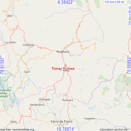
Tomay Kichwa GPS coordinates[2]
10° 4' 37.992" South, 76° 12' 42.984" West
| Map corner | latitude | longitude |
|---|---|---|
| Upper-left | -9.38422°, | -76.91507° |
| Center: | -10.07722°, | -76.21194° |
| Lower-right: | -10.76874°, | -75.50882° |
| Map W x H: | 153.9×153.9 km | = 95.6×95.6mi |
| max Lat: | -0.96667° ⇑39.7% North |
| Tomay Kichwa: | -10.07722° |
| min Lat: | ⇓60.3% South -18.01465° |
| min Long | Tomay Kichwa | max Long |
| -81.30472° | -76.21194° | -69.04167° |
| W 44.9%⇐ | ⇒55.1% E |
Elevation
Elevation of Tomay Kichwa is 2034 m = 6673 ft, and this is 284.7 m = 934 ft below average elevation for this country.
| Max E: |
5022 m = 16476 ft | 65.1% |
| Avg. | 2318.7 m = 7607 ft | |
| Tomay Kichwa | 2034 m = 6673 ft | |
Min E: |
1 m = 3 ft | 34.9% |
See also: Peru elevation on elevation.city.
Geographical zone
Tomay Kichwa is located in South Torrid zone (between Equator and Tropic of Capricorn). Distance of Equator is 1120.5 km =696.2 mi to North.| Distance of | km | miles | from Tomay Kichwa |
|---|---|---|---|
| Equator | 1120.5 | 696.2 | to North |
| Tropic Capricorn | 1485.4 | 923 | to South |
| Antarctic Circle | 6280.7 | 3902.6 | to South |
| South Pole | 8886.6 | 5521.9 | to South |


Nearby cities:
15 places around Tomay Kichwa: (largest is in red/bold)
• Acomayo
34.3 km =21.3 mi,  26°
26°
• Ambo
6 km =3.7 mi,  172°
172°
• Cayhuayna
13.8 km =8.6 mi,  343°
343°
• Cayna
29 km =18 mi,  221°
221°
• Churubamba
29.3 km =18.2 mi,  17°
17°
• Colpas
30.7 km =19.1 mi,  226°
226°
• Conchamarca
4.4 km =2.7 mi,  355°
355°
• Huacar
9.6 km =6 mi,  196°
196°
• Huancapallac
30.1 km =18.7 mi,  312°
312°
• Huánuco
16.6 km =10.3 mi,  348°
348°
• Margos
34.9 km =21.7 mi,  283°
283°
• Mosca
30.8 km =19.1 mi, 196°
• Panao
31.2 km =19.4 mi,  50°
50°
• Paucarbamba
14.8 km =9.2 mi, 355°
• San Rafael
29.2 km =18.1 mi, 173°
Sources, notices
• [Note1] Compared only with cities in Peru existing in our database
• [Src1] Map data: © OpenStreetMap contributors (CC-BY-SA)
• [Src2] Other city data from geonames.org with taken over terms of usage.
• [Src3] Geographical zone / Annual Mean Temperature by Robert A. Rohde @ Wikipedia
