Palca geodata
Palca (Tacna) is a seat of a third-order administrative division; located in Peru in America/Lima (GMT-5) time zone. In our database, there are 305 cities with bigger population. Compared to other cities in Peru, 99.5% of cities are located further ↑North; 96.9% of cities are located further ←West and 53.7% of cities have lower elevation than Palca. Note1


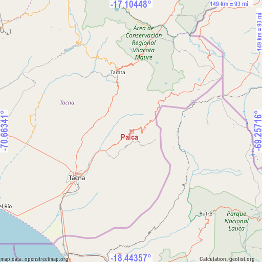
Palca GPS coordinates[2]
17° 46' 31.008" South, 69° 57' 37.008" West
| Map corner | latitude | longitude |
|---|---|---|
| Upper-left | -17.10448°, | -70.66341° |
| Center: | -17.77528°, | -69.96028° |
| Lower-right: | -18.44357°, | -69.25716° |
| Map W x H: | 148.9×148.9 km | = 92.5×92.5mi |
| max Lat: | -0.96667° ⇑99.5% North |
| Palca: | -17.77528° |
| min Lat: | ⇓0.5% South -18.01465° |
| min Long | Palca | max Long |
| -81.30472° | -69.96028° | -69.04167° |
| W 96.9%⇐ | ⇒3.1% E |
Elevation
Elevation of Palca is 2992 m = 9816 ft, and this is 673.3 m = 2209 ft above average elevation for this country.
| Max E: |
5022 m = 16476 ft | 46.3% |
| Palca | 2992 m 9816 ft | |
| Avg. | 2318.7 m = 7607 ft | |
Min E: |
1 m = 3 ft | 53.7% |
See also: Peru elevation on elevation.city.
Geographical zone
Palca is located in South Torrid zone (between Equator and Tropic of Capricorn). Distance of this Southern Tropic circle is 629.5 km =391.2 mi to South.| Distance of | km | miles | from Palca |
|---|---|---|---|
| Equator | 1976.4 | 1228.1 | to North |
| Tropic Capricorn | 629.5 | 391.2 | to South |
| Antarctic Circle | 5424.7 | 3370.8 | to South |
| South Pole | 8030.6 | 4990 | to South |


Nearby cities:
15 places around Palca: (largest is in red/bold)
• Calana
30.3 km =18.8 mi,  232°
232°
• Chipispaya
41.1 km =25.5 mi,  318°
318°
• Chucatamani
37 km =23 mi,  332°
332°
• Chuquitira
54.8 km =34.1 mi,  350°
350°
• Curibaya
59 km =36.7 mi, 317°
• Estique
26.7 km =16.6 mi, 346°
• Pocollay
36 km =22.4 mi, 228°
• Sama Grande
56.6 km =35.2 mi,  268°
268°
• Sitajara
48 km =29.8 mi,  337°
337°
• Sobraya
34.8 km =21.6 mi, 225°
• Susapaya
50.3 km =31.3 mi, 338°
• Tacna
40.9 km =25.4 mi, 229°
• Tarata
34.3 km =21.3 mi, 347°
• Tarucachi
28.8 km =17.9 mi, 345°
• Ticaco
37.7 km =23.4 mi, 345°
Sources, notices
• [Note1] Compared only with cities in Peru existing in our database
• [Src1] Map data: © OpenStreetMap contributors (CC-BY-SA)
• [Src2] Other city data from geonames.org with taken over terms of usage.
• [Src3] Geographical zone / Annual Mean Temperature by Robert A. Rohde @ Wikipedia
