Calana geodata
Calana (Tacna) is a seat of a third-order administrative division; located in Peru in America/Lima (GMT-5) time zone. With population of 875 people, there are 301 cities with bigger population in this country. Compared to other cities in Peru, 99.8% of cities are located further ↑North; 95% of cities are located further ←West and 73.3% of cities have higher elevation than Calana. Note1


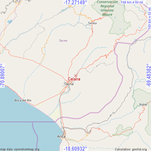
Calana GPS coordinates[2]
17° 56' 30.012" South, 70° 11' 12.984" West
| Map corner | latitude | longitude |
|---|---|---|
| Upper-left | -17.27149°, | -70.89007° |
| Center: | -17.94167°, | -70.18694° |
| Lower-right: | -18.60932°, | -69.48382° |
| Map W x H: | 148.8×148.8 km | = 92.5×92.5mi |
| max Lat: | -0.96667° ⇑99.8% North |
| Calana: | -17.94167° |
| min Lat: | ⇓0.2% South -18.01465° |
| min Long | Calana | max Long |
| -81.30472° | -70.18694° | -69.04167° |
| W 95%⇐ | ⇒5% E |
Elevation
Elevation of Calana is 896 m = 2940 ft, and this is 1422.7 m = 4668 ft below average elevation for this country.
| Max E: |
5022 m = 16476 ft | 73.3% |
| Avg. | 2318.7 m = 7607 ft | |
| Calana | 896 m = 2940 ft | |
Min E: |
1 m = 3 ft | 26.7% |
See also: Peru elevation on elevation.city.
Geographical zone
Calana is located in South Torrid zone (between Equator and Tropic of Capricorn). Distance of this Southern Tropic circle is 611 km =379.7 mi to South.| Distance of | km | miles | from Calana |
|---|---|---|---|
| Equator | 1994.9 | 1239.6 | to North |
| Tropic Capricorn | 611 | 379.7 | to South |
| Antarctic Circle | 5406.2 | 3359.3 | to South |
| South Pole | 8012.1 | 4978.5 | to South |


Nearby cities:
15 places around Calana: (largest is in red/bold)
• Chipispaya
49.4 km =30.7 mi,  356°
356°
• Chucatamani
51.7 km =32.1 mi,  7°
7°
• Curibaya
64.1 km =39.8 mi,  345°
345°
• Estique
47.9 km =29.8 mi,  21°
21°
• Las Yaras
40.7 km =25.3 mi,  282°
282°
• Palca
30.3 km =18.8 mi,  52°
52°
• Pocollay
6.2 km =3.9 mi,  206°
206°
• Sama Grande
36.6 km =22.7 mi,  296°
296°
• Sitajara
63.2 km =39.3 mi, 5°
• Sobraya
6 km =3.7 mi,  188°
188°
• Tacna
10.8 km =6.7 mi,  220°
220°
• Tarata
54.5 km =33.9 mi, 17°
• Tarucachi
49.3 km =30.6 mi, 19°
• Ticaco
57 km =35.4 mi, 15°
• Totoral
62.4 km =38.8 mi,  342°
342°
Sources, notices
• [Note1] Compared only with cities in Peru existing in our database
• [Src1] Map data: © OpenStreetMap contributors (CC-BY-SA)
• [Src2] Other city data from geonames.org with taken over terms of usage.
• [Src3] Geographical zone / Annual Mean Temperature by Robert A. Rohde @ Wikipedia
