Tacna geodata
Tacna is a seat of a first-order administrative division; located in Peru in America/Lima (GMT-5) time zone. With population of 280,098 people, there are 11 cities with bigger population in this country. Compared to other cities in Peru, 100% of cities are located further ↑North; 94.1% of cities are located further ←West and 77.2% of cities have higher elevation than Tacna. Note1


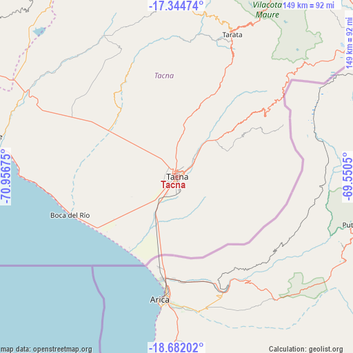
Tacna GPS coordinates[2]
18° 0' 52.74" South, 70° 15' 13.032" West
| Map corner | latitude | longitude |
|---|---|---|
| Upper-left | -17.34474°, | -70.95675° |
| Center: | -18.01465°, | -70.25362° |
| Lower-right: | -18.68202°, | -69.5505° |
| Map W x H: | 148.7×148.7 km | = 92.4×92.4mi |
| max Lat: | -0.96667° ⇑100% North |
| Tacna: | -18.01465° |
| min Lat: | ⇓0% South -18.01465° |
| min Long | Tacna | max Long |
| -81.30472° | -70.25362° | -69.04167° |
| W 94.1%⇐ | ⇒5.9% E |
Elevation
Elevation of Tacna is 567 m = 1860 ft, and this is 1751.7 m = 5747 ft below average elevation for this country.
| Max E: |
5022 m = 16476 ft | 77.2% |
| Avg. | 2318.7 m = 7607 ft | |
| Tacna | 567 m = 1860 ft | |
Min E: |
1 m = 3 ft | 22.8% |
See also: Tacna elevation on elevation.city.
Geographical zone
Tacna is located in South Torrid zone (between Equator and Tropic of Capricorn). Distance of this Southern Tropic circle is 602.9 km =374.6 mi to South.| Distance of | km | miles | from Tacna |
|---|---|---|---|
| Equator | 2003 | 1244.6 | to North |
| Tropic Capricorn | 602.9 | 374.6 | to South |
| Antarctic Circle | 5398.1 | 3354.2 | to South |
| South Pole | 8004 | 4973.5 | to South |


Nearby cities:
15 places around Tacna: (largest is in red/bold)
• Calana
10.8 km =6.7 mi,  40°
40°
• Chipispaya
57.6 km =35.8 mi,  3°
3°
• Chucatamani
61 km =37.9 mi,  13°
13°
• Curibaya
70.8 km =44 mi,  353°
353°
• Estique
58.2 km =36.2 mi,  25°
25°
• Las Yaras
36.7 km =22.8 mi,  297°
297°
• Locumba
70 km =43.5 mi,  309°
309°
• Palca
40.9 km =25.4 mi,  49°
49°
• Pocollay
5 km =3.1 mi,  59°
59°
• Sama Grande
35.5 km =22.1 mi, 314°
• Sobraya
6.6 km =4.1 mi,  70°
70°
• Tarata
64.5 km =40.1 mi,  21°
21°
• Tarucachi
59.5 km =37 mi, 23°
• Ticaco
66.9 km =41.6 mi, 19°
• Totoral
68.7 km =42.7 mi, 350°
Sources, notices
• [Note1] Compared only with cities in Peru existing in our database
• [Src1] Map data: © OpenStreetMap contributors (CC-BY-SA)
• [Src2] Other city data from geonames.org with taken over terms of usage.
• [Src3] Geographical zone / Annual Mean Temperature by Robert A. Rohde @ Wikipedia
