Antauta geodata
Antauta (Puno) is a seat of a third-order administrative division; located in Peru in America/Lima (GMT-5) time zone. In our database, there are 305 cities with bigger population. Compared to other cities in Peru, 81.6% of cities are located further ↑North; 93.2% of cities are located further ←West and 99.8% of cities have lower elevation than Antauta. Note1


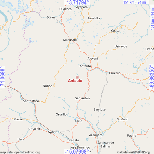
Antauta GPS coordinates[2]
14° 24' 0" South, 70° 22' 0.012" West
| Map corner | latitude | longitude |
|---|---|---|
| Upper-left | -13.71794°, | -71.0698° |
| Center: | -14.4°, | -70.36667° |
| Lower-right: | -15.07998°, | -69.66355° |
| Map W x H: | 151.4×151.4 km | = 94.1×94.1mi |
| max Lat: | -0.96667° ⇑81.6% North |
| Antauta: | -14.4° |
| min Lat: | ⇓18.4% South -18.01465° |
| min Long | Antauta | max Long |
| -81.30472° | -70.36667° | -69.04167° |
| W 93.2%⇐ | ⇒6.8% E |
Elevation
Elevation of Antauta is 4775 m = 15666 ft, and this is 2456.3 m = 8059 ft above average elevation for this country.
| Max E: |
5022 m = 16476 ft | 0.2% |
| Antauta | 4775 m 15666 ft | |
| Avg. | 2318.7 m = 7607 ft | |
Min E: |
1 m = 3 ft | 99.8% |
See also: Peru elevation on elevation.city.
Geographical zone
Antauta is located in South Torrid zone (between Equator and Tropic of Capricorn). Distance of this Southern Tropic circle is 1004.8 km =624.4 mi to South.| Distance of | km | miles | from Antauta |
|---|---|---|---|
| Equator | 1601.1 | 994.9 | to North |
| Tropic Capricorn | 1004.8 | 624.4 | to South |
| Antarctic Circle | 5800 | 3604 | to South |
| South Pole | 8405.9 | 5223.2 | to South |


Nearby cities:
15 places around Antauta: (largest is in red/bold)
• Ajoyani
37.9 km =23.5 mi,  28°
28°
• Asillo
42.7 km =26.5 mi,  177°
177°
• Ayaviri
59.1 km =36.7 mi,  203°
203°
• Azángaro
59.4 km =36.9 mi,  162°
162°
• Coasa
61.9 km =38.5 mi,  44°
44°
• Corani
64.2 km =39.9 mi,  336°
336°
• Crucero
39.9 km =24.8 mi,  81°
81°
• Macusani
35.9 km =22.3 mi,  348°
348°
• Muñani
60.6 km =37.7 mi,  132°
132°
• Orurillo
39.9 km =24.8 mi, 203°
• Potoni
30.6 km =19 mi,  86°
86°
• Santa Rosa
50.9 km =31.6 mi,  242°
242°
• Tirapata
61.3 km =38.1 mi, 183°
• Usicayos
52.9 km =32.9 mi,  54°
54°
• Ñuñoa
30.2 km =18.8 mi,  253°
253°
Sources, notices
• [Note1] Compared only with cities in Peru existing in our database
• [Src1] Map data: © OpenStreetMap contributors (CC-BY-SA)
• [Src2] Other city data from geonames.org with taken over terms of usage.
• [Src3] Geographical zone / Annual Mean Temperature by Robert A. Rohde @ Wikipedia
