Macusani geodata
Macusani (Puno) is a seat of a third-order administrative division; located in Peru in America/Lima (GMT-5) time zone. With population of 6,044 people, there are 206 cities with bigger population in this country. Compared to other cities in Peru, 75.4% of cities are located further ↑North; 92.9% of cities are located further ←West and 98.6% of cities have lower elevation than Macusani. Note1


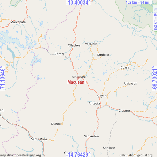
Macusani GPS coordinates[2]
14° 4' 59.988" South, 70° 25' 59.988" West
| Map corner | latitude | longitude |
|---|---|---|
| Upper-left | -13.40034°, | -71.13646° |
| Center: | -14.08333°, | -70.43333° |
| Lower-right: | -14.76429°, | -69.73021° |
| Map W x H: | 151.7×151.7 km | = 94.3×94.3mi |
| max Lat: | -0.96667° ⇑75.4% North |
| Macusani: | -14.08333° |
| min Lat: | ⇓24.6% South -18.01465° |
| min Long | Macusani | max Long |
| -81.30472° | -70.43333° | -69.04167° |
| W 92.9%⇐ | ⇒7.1% E |
Elevation
Elevation of Macusani is 4360 m = 14304 ft, and this is 2041.3 m = 6697 ft above average elevation for this country.
| Max E: |
5022 m = 16476 ft | 1.4% |
| Macusani | 4360 m 14304 ft | |
| Avg. | 2318.7 m = 7607 ft | |
Min E: |
1 m = 3 ft | 98.6% |
See also: Peru elevation on elevation.city.
Geographical zone
Macusani is located in South Torrid zone (between Equator and Tropic of Capricorn). Distance of this Southern Tropic circle is 1040 km =646.2 mi to South.| Distance of | km | miles | from Macusani |
|---|---|---|---|
| Equator | 1565.9 | 973 | to North |
| Tropic Capricorn | 1040 | 646.2 | to South |
| Antarctic Circle | 5835.3 | 3625.9 | to South |
| South Pole | 8441.1 | 5245.1 | to South |


Nearby cities:
15 places around Macusani: (largest is in red/bold)
• Ajoyani
25.2 km =15.7 mi,  94°
94°
• Antauta
35.9 km =22.3 mi,  168°
168°
• Callanca
77 km =47.8 mi,  261°
261°
• Coasa
51.2 km =31.8 mi,  79°
79°
• Corani
30.1 km =18.7 mi,  321°
321°
• Crucero
55.3 km =34.4 mi,  122°
122°
• Huayna Alcalde
74.4 km =46.2 mi,  253°
253°
• Lanlacuni Bajo
66.7 km =41.4 mi,  1°
1°
• Mosoc Cancha
74 km =46 mi, 252°
• Ollachea
30.1 km =18.7 mi,  349°
349°
• Orurillo
72.4 km =45 mi,  186°
186°
• Potoni
50.4 km =31.3 mi,  131°
131°
• Santa Rosa
69.9 km =43.4 mi,  212°
212°
• Usicayos
50.6 km =31.4 mi,  95°
95°
• Ñuñoa
49 km =30.4 mi, 206°
Sources, notices
• [Note1] Compared only with cities in Peru existing in our database
• [Src1] Map data: © OpenStreetMap contributors (CC-BY-SA)
• [Src2] Other city data from geonames.org with taken over terms of usage.
• [Src3] Geographical zone / Annual Mean Temperature by Robert A. Rohde @ Wikipedia
