Mangas geodata
Mangas (Ancash) is a seat of a third-order administrative division; located in Peru in America/Lima (GMT-5) time zone. In our database, there are 305 cities with bigger population. Compared to other cities in Peru, 58.4% of cities are located further ↓South; 68.3% of cities are located further →East and 81% of cities have lower elevation than Mangas. Note1


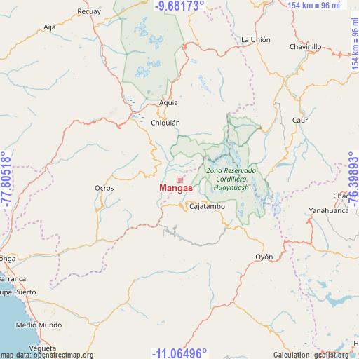
Mangas GPS coordinates[2]
10° 22' 26.796" South, 77° 6' 7.38" West
| Map corner | latitude | longitude |
|---|---|---|
| Upper-left | -9.68173°, | -77.80518° |
| Center: | -10.37411°, | -77.10205° |
| Lower-right: | -11.06496°, | -76.39893° |
| Map W x H: | 153.8×153.8 km | = 95.6×95.6mi |
| max Lat: | -0.96667° ⇑41.6% North |
| Mangas: | -10.37411° |
| min Lat: | ⇓58.4% South -18.01465° |
| min Long | Mangas | max Long |
| -81.30472° | -77.10205° | -69.04167° |
| W 31.7%⇐ | ⇒68.3% E |
Elevation
Elevation of Mangas is 3550 m = 11647 ft, and this is 1231.3 m = 4040 ft above average elevation for this country.
| Max E: |
5022 m = 16476 ft | 19% |
| Mangas | 3550 m 11647 ft | |
| Avg. | 2318.7 m = 7607 ft | |
Min E: |
1 m = 3 ft | 81% |
See also: Peru elevation on elevation.city.
Geographical zone
Mangas is located in South Torrid zone (between Equator and Tropic of Capricorn). Distance of Equator is 1153.5 km =716.8 mi to North.| Distance of | km | miles | from Mangas |
|---|---|---|---|
| Equator | 1153.5 | 716.8 | to North |
| Tropic Capricorn | 1452.4 | 902.5 | to South |
| Antarctic Circle | 6247.7 | 3882.1 | to South |
| South Pole | 8853.6 | 5501.4 | to South |


Nearby cities:
15 places around Mangas: (largest is in red/bold)
• Acas
26.3 km =16.3 mi,  249°
249°
• Aco
20.5 km =12.7 mi,  228°
228°
• Aquia
33.7 km =20.9 mi,  352°
352°
• Canis
8.3 km =5.2 mi,  297°
297°
• Congas
37.4 km =23.2 mi,  276°
276°
• Copa
2.9 km =1.8 mi,  122°
122°
• Copa
42.2 km =26.2 mi,  270°
270°
• Corpanqui
14.5 km =9 mi,  313°
313°
• Gorgor
24.4 km =15.2 mi,  162°
162°
• Huasta
28.5 km =17.7 mi, 347°
• Llaclla
9.6 km =6 mi,  330°
330°
• Llipa
11.4 km =7.1 mi, 265°
• Ocros
32.4 km =20.1 mi,  264°
264°
• Queropalca
39 km =24.2 mi,  56°
56°
• Ticllos
16.5 km =10.3 mi,  323°
323°
Sources, notices
• [Note1] Compared only with cities in Peru existing in our database
• [Src1] Map data: © OpenStreetMap contributors (CC-BY-SA)
• [Src2] Other city data from geonames.org with taken over terms of usage.
• [Src3] Geographical zone / Annual Mean Temperature by Robert A. Rohde @ Wikipedia
