Atico geodata
Atico (Arequipa) is a seat of a third-order administrative division; located in Peru in America/Lima (GMT-5) time zone. In our database, there are 305 cities with bigger population. Compared to other cities in Peru, 94.3% of cities are located further ↑North; 69% of cities are located further ←West and 90.9% of cities have higher elevation than Atico. Note1


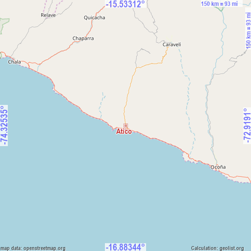
Atico GPS coordinates[2]
16° 12' 33.984" South, 73° 37' 19.992" West
| Map corner | latitude | longitude |
|---|---|---|
| Upper-left | -15.53312°, | -74.32535° |
| Center: | -16.20944°, | -73.62222° |
| Lower-right: | -16.88344°, | -72.9191° |
| Map W x H: | 150.1×150.1 km | = 93.3×93.3mi |
| max Lat: | -0.96667° ⇑94.3% North |
| Atico: | -16.20944° |
| min Lat: | ⇓5.7% South -18.01465° |
| min Long | Atico | max Long |
| -81.30472° | -73.62222° | -69.04167° |
| W 69%⇐ | ⇒31% E |
Elevation
Elevation of Atico is 80 m = 262 ft, and this is 2238.7 m = 7345 ft below average elevation for this country.
| Max E: |
5022 m = 16476 ft | 90.9% |
| Avg. | 2318.7 m = 7607 ft | |
| Atico | 80 m = 262 ft | |
Min E: |
1 m = 3 ft | 9.1% |
See also: Peru elevation on elevation.city.
Geographical zone
Atico is located in South Torrid zone (between Equator and Tropic of Capricorn). Distance of this Southern Tropic circle is 803.6 km =499.3 mi to South.| Distance of | km | miles | from Atico |
|---|---|---|---|
| Equator | 1802.3 | 1119.9 | to North |
| Tropic Capricorn | 803.6 | 499.3 | to South |
| Antarctic Circle | 5598.9 | 3479 | to South |
| South Pole | 8204.7 | 5098.2 | to South |


Nearby cities:
15 places around Atico: (largest is in red/bold)
• Achanizo
58 km =36 mi,  320°
320°
• Andaray
93.5 km =58.1 mi,  60°
60°
• Atiquipa
91.6 km =56.9 mi,  300°
300°
• Cahuacho
79.7 km =49.5 mi,  11°
11°
• Chala
76.9 km =47.8 mi, 299°
• Chichas
105.3 km =65.4 mi,  45°
45°
• El Cardo
105.1 km =65.3 mi,  114°
114°
• Incuyo
106.8 km =66.4 mi,  2°
2°
• Iquipi
60.5 km =37.6 mi, 60°
• Ocoña
60.3 km =37.5 mi, 114°
• Quicacha
67.6 km =42 mi,  343°
343°
• Tauria
103.6 km =64.4 mi,  23°
23°
• Tocota
79 km =49.1 mi, 320°
• Urasqui
52.3 km =32.5 mi,  67°
67°
• Yanaquihua
93.3 km =58 mi, 58°
Sources, notices
• [Note1] Compared only with cities in Peru existing in our database
• [Src1] Map data: © OpenStreetMap contributors (CC-BY-SA)
• [Src2] Other city data from geonames.org with taken over terms of usage.
• [Src3] Geographical zone / Annual Mean Temperature by Robert A. Rohde @ Wikipedia
