Achanizo geodata
Achanizo (Arequipa) is a seat of a third-order administrative division; located in Peru in America/Lima (GMT-5) time zone. In our database, there are 305 cities with bigger population. Compared to other cities in Peru, 92.8% of cities are located further ↑North; 66.2% of cities are located further ←West and 76.4% of cities have higher elevation than Achanizo. Note1


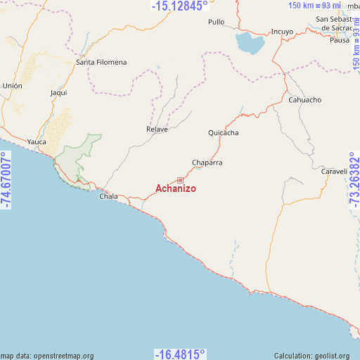
Achanizo GPS coordinates[2]
15° 48' 21.996" South, 73° 58' 0.984" West
| Map corner | latitude | longitude |
|---|---|---|
| Upper-left | -15.12845°, | -74.67007° |
| Center: | -15.80611°, | -73.96694° |
| Lower-right: | -16.4815°, | -73.26382° |
| Map W x H: | 150.4×150.4 km | = 93.5×93.5mi |
| max Lat: | -0.96667° ⇑92.8% North |
| Achanizo: | -15.80611° |
| min Lat: | ⇓7.2% South -18.01465° |
| min Long | Achanizo | max Long |
| -81.30472° | -73.96694° | -69.04167° |
| W 66.2%⇐ | ⇒33.8% E |
Elevation
Elevation of Achanizo is 619 m = 2031 ft, and this is 1699.7 m = 5576 ft below average elevation for this country.
| Max E: |
5022 m = 16476 ft | 76.4% |
| Avg. | 2318.7 m = 7607 ft | |
| Achanizo | 619 m = 2031 ft | |
Min E: |
1 m = 3 ft | 23.6% |
See also: Peru elevation on elevation.city.
Geographical zone
Achanizo is located in South Torrid zone (between Equator and Tropic of Capricorn). Distance of this Southern Tropic circle is 848.4 km =527.2 mi to South.| Distance of | km | miles | from Achanizo |
|---|---|---|---|
| Equator | 1757.5 | 1092.1 | to North |
| Tropic Capricorn | 848.4 | 527.2 | to South |
| Antarctic Circle | 5643.7 | 3506.8 | to South |
| South Pole | 8249.6 | 5126.1 | to South |


Nearby cities:
15 places around Achanizo: (largest is in red/bold)
• Acarí
81.2 km =50.5 mi,  301°
301°
• Atico
58 km =36 mi,  140°
140°
• Atiquipa
42.5 km =26.4 mi,  271°
271°
• Cahuacho
62 km =38.5 mi,  57°
57°
• Chala
30.7 km =19.1 mi,  257°
257°
• Chumpi
81.4 km =50.6 mi,  15°
15°
• Coracora
88.2 km =54.8 mi,  12°
12°
• Incuyo
74.2 km =46.1 mi,  33°
33°
• Pausa
88.6 km =55.1 mi,  48°
48°
• Pullo
67.5 km =41.9 mi, 13°
• Quicacha
27 km =16.8 mi,  41°
41°
• Quilcata
82.9 km =51.5 mi, 41°
• Tocota
21 km =13 mi,  320°
320°
• Urasqui
88.7 km =55.1 mi,  106°
106°
• Yauca
62.1 km =38.6 mi,  285°
285°
Sources, notices
• [Note1] Compared only with cities in Peru existing in our database
• [Src1] Map data: © OpenStreetMap contributors (CC-BY-SA)
• [Src2] Other city data from geonames.org with taken over terms of usage.
• [Src3] Geographical zone / Annual Mean Temperature by Robert A. Rohde @ Wikipedia
