Vizcachane geodata
Vizcachane (Arequipa) is a populated place; located in Peru in America/Lima (GMT-5) time zone. With population of 4,407 people, there are 252 cities with bigger population in this country. Compared to other cities in Peru, 92.9% of cities are located further ↑North; 88.9% of cities are located further ←West and 98.9% of cities have lower elevation than Vizcachane. Note1
Administrative division(s):
- Level 1: Arequipa
- Level 2: Provincia de Caylloma
- Level 3: San Antonio De Chuca


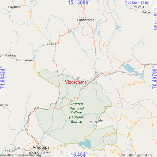
Vizcachane GPS coordinates[2]
15° 48' 30.996" South, 71° 12' 3.996" West
| Map corner | latitude | longitude |
|---|---|---|
| Upper-left | -15.13096°, | -71.90424° |
| Center: | -15.80861°, | -71.20111° |
| Lower-right: | -16.484°, | -70.49799° |
| Map W x H: | 150.4×150.4 km | = 93.5×93.5mi |
| max Lat: | -0.96667° ⇑92.9% North |
| Vizcachane: | -15.80861° |
| min Lat: | ⇓7.1% South -18.01465° |
| min Long | Vizcachane | max Long |
| -81.30472° | -71.20111° | -69.04167° |
| W 88.9%⇐ | ⇒11.1% E |
Elevation
Elevation of Vizcachane is 4432 m = 14541 ft, and this is 2113.3 m = 6933 ft above average elevation for this country.
| Max E: |
5022 m = 16476 ft | 1.1% |
| Vizcachane | 4432 m 14541 ft | |
| Avg. | 2318.7 m = 7607 ft | |
Min E: |
1 m = 3 ft | 98.9% |
See also: Peru elevation on elevation.city.
Geographical zone
Vizcachane is located in South Torrid zone (between Equator and Tropic of Capricorn). Distance of this Southern Tropic circle is 848.2 km =527 mi to South.| Distance of | km | miles | from Vizcachane |
|---|---|---|---|
| Equator | 1757.8 | 1092.2 | to North |
| Tropic Capricorn | 848.2 | 527 | to South |
| Antarctic Circle | 5643.4 | 3506.6 | to South |
| South Pole | 8249.3 | 5125.9 | to South |


Nearby cities:
15 places around Vizcachane: (largest is in red/bold)
• Callalli
42.4 km =26.3 mi,  321°
321°
• Ccolo
45.8 km =28.5 mi, 317°
• Chivay
46.8 km =29.1 mi,  293°
293°
• Coporaque
51.7 km =32.1 mi, 292°
• Hacienda Huancane
33.8 km =21 mi,  92°
92°
• Huarancante
28 km =17.4 mi,  279°
279°
• Huarichancara
24 km =14.9 mi,  38°
38°
• Jatun Orcochiri
16.9 km =10.5 mi, 292°
• Jayune
29.4 km =18.3 mi,  338°
338°
• Llongasora
21.5 km =13.4 mi,  330°
330°
• Pucara
33.6 km =20.9 mi,  235°
235°
• Sibayo
45.1 km =28 mi, 322°
• Tarucani
44.1 km =27.4 mi,  160°
160°
• Tuti
48.4 km =30.1 mi,  309°
309°
• Yanque
52 km =32.3 mi, 289°
Sources, notices
• [Note1] Compared only with cities in Peru existing in our database
• [Src1] Map data: © OpenStreetMap contributors (CC-BY-SA)
• [Src2] Other city data from geonames.org with taken over terms of usage.
• [Src3] Geographical zone / Annual Mean Temperature by Robert A. Rohde @ Wikipedia
