Kelluyo geodata
Kelluyo (Puno) is a seat of a third-order administrative division; located in Peru in America/Lima (GMT-5) time zone. In our database, there are 305 cities with bigger population. Compared to other cities in Peru, 96.7% of cities are located further ↑North; 99.6% of cities are located further ←West and 92% of cities have lower elevation than Kelluyo. Note1


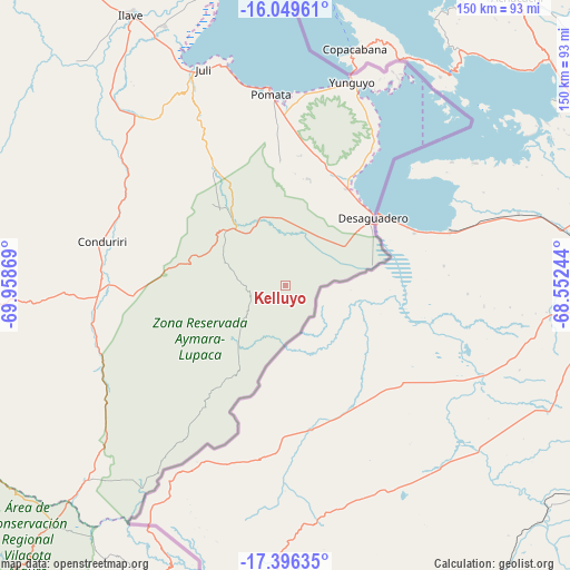
Kelluyo GPS coordinates[2]
16° 43' 27.012" South, 69° 15' 20.016" West
| Map corner | latitude | longitude |
|---|---|---|
| Upper-left | -16.04961°, | -69.95869° |
| Center: | -16.72417°, | -69.25556° |
| Lower-right: | -17.39635°, | -68.55244° |
| Map W x H: | 149.7×149.7 km | = 93×93mi |
| max Lat: | -0.96667° ⇑96.7% North |
| Kelluyo: | -16.72417° |
| min Lat: | ⇓3.3% South -18.01465° |
| min Long | Kelluyo | max Long |
| -81.30472° | -69.25556° | -69.04167° |
| W 99.6%⇐ | ⇒0.40000000000001% E |
Elevation
Elevation of Kelluyo is 3907 m = 12818 ft, and this is 1588.3 m = 5211 ft above average elevation for this country.
| Max E: |
5022 m = 16476 ft | 8% |
| Kelluyo | 3907 m 12818 ft | |
| Avg. | 2318.7 m = 7607 ft | |
Min E: |
1 m = 3 ft | 92% |
See also: Peru elevation on elevation.city.
Geographical zone
Kelluyo is located in South Torrid zone (between Equator and Tropic of Capricorn). Distance of this Southern Tropic circle is 746.4 km =463.8 mi to South.| Distance of | km | miles | from Kelluyo |
|---|---|---|---|
| Equator | 1859.6 | 1155.5 | to North |
| Tropic Capricorn | 746.4 | 463.8 | to South |
| Antarctic Circle | 5541.6 | 3443.4 | to South |
| South Pole | 8147.5 | 5062.6 | to South |


Nearby cities:
15 places around Kelluyo: (largest is in red/bold)
• Chuquitira
104.7 km =65.1 mi,  233°
233°
• Desaguadero
28.8 km =17.9 mi,  52°
52°
• Ilave
83.7 km =52 mi,  328°
328°
• Juli
60.1 km =37.3 mi,  339°
339°
• Laraqueri
107.2 km =66.6 mi,  307°
307°
• Mazo Cruz
51 km =31.7 mi,  266°
266°
• Pilcuyo
76.9 km =47.8 mi, 334°
• Pomata
51.1 km =31.8 mi,  354°
354°
• Sitajara
118 km =73.3 mi, 232°
• Susapaya
116.5 km =72.4 mi, 233°
• Taquile
115.8 km =72 mi, 336°
• Tarata
117.4 km =72.9 mi,  224°
224°
• Ticaco
116.3 km =72.3 mi, 226°
• Yunguyo
55.8 km =34.7 mi,  19°
19°
• Zepita
29.9 km =18.6 mi,  33°
33°
Sources, notices
• [Note1] Compared only with cities in Peru existing in our database
• [Src1] Map data: © OpenStreetMap contributors (CC-BY-SA)
• [Src2] Other city data from geonames.org with taken over terms of usage.
• [Src3] Geographical zone / Annual Mean Temperature by Robert A. Rohde @ Wikipedia
