Desaguadero geodata
Desaguadero (Puno) is a seat of a third-order administrative division; located in Peru in America/Lima (GMT-5) time zone. With population of 5,329 people, there are 228 cities with bigger population in this country. Compared to other cities in Peru, 96.1% of cities are located further ↑North; 100% of cities are located further ←West and 89.5% of cities have lower elevation than Desaguadero. Note1


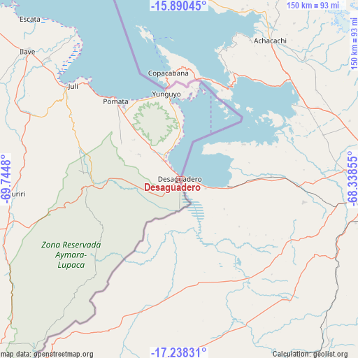
Desaguadero GPS coordinates[2]
16° 33' 56.016" South, 69° 2' 30.012" West
| Map corner | latitude | longitude |
|---|---|---|
| Upper-left | -15.89045°, | -69.7448° |
| Center: | -16.56556°, | -69.04167° |
| Lower-right: | -17.23831°, | -68.33855° |
| Map W x H: | 149.9×149.9 km | = 93.1×93.1mi |
| max Lat: | -0.96667° ⇑96.1% North |
| Desaguadero: | -16.56556° |
| min Lat: | ⇓3.9% South -18.01465° |
| min Long | Desaguadero | max Long |
| -81.30472° | -69.04167° | -69.04167° |
| W 100%⇐ | ⇒0% E |
Elevation
Elevation of Desaguadero is 3830 m = 12566 ft, and this is 1511.3 m = 4958 ft above average elevation for this country.
| Max E: |
5022 m = 16476 ft | 10.5% |
| Desaguadero | 3830 m 12566 ft | |
| Avg. | 2318.7 m = 7607 ft | |
Min E: |
1 m = 3 ft | 89.5% |
See also: Peru elevation on elevation.city.
Geographical zone
Desaguadero is located in South Torrid zone (between Equator and Tropic of Capricorn). Distance of this Southern Tropic circle is 764 km =474.7 mi to South.| Distance of | km | miles | from Desaguadero |
|---|---|---|---|
| Equator | 1841.9 | 1144.5 | to North |
| Tropic Capricorn | 764 | 474.7 | to South |
| Antarctic Circle | 5559.3 | 3454.4 | to South |
| South Pole | 8165.1 | 5073.6 | to South |


Nearby cities:
15 places around Desaguadero: (largest is in red/bold)
• Capachica
132.7 km =82.5 mi,  321°
321°
• Chuquitira
133.5 km =83 mi,  232°
232°
• Conima
132.7 km =82.5 mi,  341°
341°
• Ilave
85.6 km =53.2 mi,  308°
308°
• Juli
58.3 km =36.2 mi, 311°
• Kelluyo
28.8 km =17.9 mi, 232°
• Laraqueri
117.8 km =73.2 mi,  294°
294°
• Mazo Cruz
76.5 km =47.5 mi,  254°
254°
• Pilcuyo
76.3 km =47.4 mi, 312°
• Pomata
43.2 km =26.8 mi, 320°
• Puno
131.8 km =81.9 mi, 307°
• Putina
128.1 km =79.6 mi, 340°
• Taquile
112.2 km =69.7 mi, 322°
• Yunguyo
35.4 km =22 mi,  352°
352°
• Zepita
9.6 km =6 mi, 319°
Sources, notices
• [Note1] Compared only with cities in Peru existing in our database
• [Src1] Map data: © OpenStreetMap contributors (CC-BY-SA)
• [Src2] Other city data from geonames.org with taken over terms of usage.
• [Src3] Geographical zone / Annual Mean Temperature by Robert A. Rohde @ Wikipedia
